
Existed: 1923 – present Length 55.63 km | Constructed 1923 | |
 | ||
Counties | ||
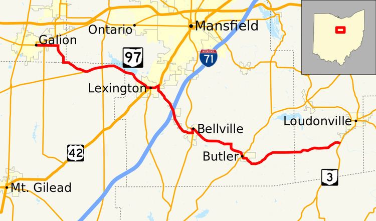
State Route 97 (SR 97) is a 34.57-mile (55.64 km) state route that runs between Galion and south of Loudonville in the US state of Ohio. Most of the route is a rural two-lane highway and passes through woodland, farmland and residential properties. For some of its path, SR 97 runs near the Clear Fork Mohican River.
Contents
Map of OH-97, Ohio, USA
The highway was first signed in 1923 on a section of the current alignment. The route has been extended a few times; the first in 1926 extending the route to SR 3. The first section of road was paved in 1938. Another extension happened in 1939 with the route heading west to Galion. The final section to be paved was done between in the mid-1950s.
Route description
SR 97 begins at an intersection with SR 19, SR 61, and SR 309. SR 19 and SR 97 head concurrently to the east, as a two-lane highway passing through residential properties. The concurrency ends at a traffic signal, when SR 19 turns towards the south and SR 97 continues towards the east. SR 97 leaves Galion and makes a sharp curve heading towards the south, before another sharp curve towards the east–southeast. The highway passes through farmland and Blooming Grove, before having a T-intersection with the eastern terminus of SR 288. East of SR 288, the route curves towards the northeast, having an intersection with SR 314. After the intersection at SR 314, SR 97 turns towards the southeast and passes to the southwest of Clear Fork Reservoir. While paralleling the reservoir the highway enters Richland County. After the reservoir ends the highway enters Lexington. The highway passes through residential properties, before having a T-intersection with U.S. Route 42 (US 42).
US 42 and SR 97 head east, having an intersection with the northern terminus of SR 546. After SR 546, the concurrency crosses the Clear Fork Mohican River and the road curves towards the northeast, passing through commercial properties. SR 97 turns towards the south leaving US 42. The route passes through commercial and industrial properties, before leaving Lexington. After Lexington the highway curves towards the southeast and passes through farmland. The highway enters Bellville and has an interchange with Interstate 71 (I–71). The route crosses over the Clear Fork Mohican River again, before curving due east, passing through residential properties. The route has a T-intersection with SR 13, this intersection is the southern terminus of the concurrency between the two routes. The two routes head north passing through downtown Bellville and crossing the Clear Fork Mohican River, before SR 97 turns towards the southeast leaving SR 13. The highway passes through commercial properties, before leaving Bellville.
East of Bellville SR 97 curves towards the east, passing through farmland and woodland. The route makes a sharp turn towards the south-southeast crossing the Clear Fork Mohican River for the final time. After crossing the river, SR 97 enters Butler and passes through residential properties, before beginning a concurrency with SR 95. The concurrency curves towards the east, before ending, with SR 95 heading due north and SR 97 continuing towards the east. The highway curves southeasterly, before leaving Butler. East of Butler the road curves towards the northeast, passing through woodland and farmland as a two-lane highway. The highway curves towards the east, before entering Ashland County. In Ashland County the route passes through the Mohican-Memorial State Forest and the Mohican State Park. The highway ends at an intersection with SR 3 in rural Hanover Township, Ashland County. Continuing east after SR 97 ends is Township Road 629. Only the section of SR 97 that is concurrent with SR 13 is incorporated within the National Highway System.
History
SR 97 was first commissioned in 1923, between Lexington and Bellville. In 1926 the route was extended east to its current east terminus at SR 3. The entire route from Lexington to SR 3 was paved by 1938. The highway was extended west to Galion in 1939, with the road was paved between Galion and SR 545, current SR 288. The final section of SR 97, between SR 288 and Lexington, was paved between 1953 and 1955.