Girish Mahajan (Editor)

Ohio State Route 120

Updated on
Edit
Like
Comment
Share on FacebookTweet on TwitterShare on LinkedInShare on Reddit
Existed:
  
1940 – present

Length
  
60.7 km

East end:
  
SR 65 in Toledo

Constructed
  
1940

Ohio State Route 120

West end:
  
Michigan state line near Lyons (old M-120)

Counties
  
Fulton County, Ohio, Lucas County, Ohio

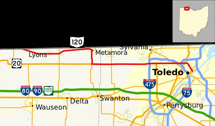
State Route 120 (SR 120) is an east–west state highway in the northwestern portion of the U.S. state of Ohio. Its western terminus is at the Michigan state line, where an unnumbered county highway (Morenci Road, formerly M-120) continues west-northwest. State Route 120’s eastern terminus is in Toledo at State Route 65; the route is, for all practical purposes, a spur of U.S. Route 20, which generally bypasses Toledo to the west and south.

Contents

Map of OH-120, Ohio, USA

History

  • 1940 – Original route certified; originally routed along its current alignment from the Michigan state line to Metamora, along currently unnumbered roads from Metamora to U.S. Route 20 in Ottawa Hills by way of Sylvania, along its current alignment from U.S. Route 20 to Downtown Toledo, a currently unnumbered road from Downtown Toledo to 1-mile (1.6 km) east of Toledo, and current State Route 51 from 1-mile (1.6 km) east of Toledo to 5 miles (8.0 km) east of Elmore.
  • 1946 – Routed to its current alignment from Metamora to Ottawa Hills by way of the village of Assumption and concurrent with U.S. Route 20; Metamora to Sylvania decertified; Sylvania to Ottawa Hills certified as State Route 333 (now defunct).
  • 1955 – Rerouted from 7 miles (11 km) east of Toledo to the village of Lemoyne along new 4-lane highway; former routing from 7 miles (11 km) east of Toledo to Elmore certified as State Route 51.
  • 1959 – Rerouted from Downtown Toledo to 5 miles (8.0 km) east of Toledo along current State Route 65 and Interstate 280.
  • 1962 – Dually certified with Interstate 280 from 1-mile (1.6 km) east of Toledo to 5 miles (8.0 km) east of Toledo.
  • 1966 – 5 miles (8.0 km) east of Toledo to Interstate 80 upgraded to freeway and dually certified with Interstate 280.
  • 1970 – Truncated at its current eastern terminus in Downtown Toledo; from Downtown Toledo to 1-mile (1.6 km) east of Toledo certified solely as State Route 65; 1 mile (1.6 km) east of Toledo to Interstate 80 certified solely as Interstate 280; Interstate 80 to Lemoyne certified as State Route 420.
  • 1972 – Rerouted from 2 miles (3.2 km) west of Downtown Toledo due east to Interstate 280 via Central Avenue; 2 miles (3.2 km) west of Downtown Toledo to Downtown Toledo (Cherry Street) decertified.
  • 1989 – Moved back to its original alignment from 2 miles (3.2 km) west of Downtown Toledo to Downtown Toledo via Cherry Street; alignment to Interstate 280 decertified after Central Avenue interchange with I-280 removed.
  • Before 1940

  • 1923–1939 – Routed along the current alignment of State Route 185 from U.S. Route 127 northwest of Versailles to Piqua; this route certified as State Route 185 in 1940.
  • References

    Ohio State Route 120 Wikipedia