
Admin. region Swabia Municipal assoc. Oettingen in Bayern Population 5,047 (31 Dec 2008) | District Donau-Ries Elevation 419 m (1,375 ft) Local time Wednesday 10:15 PM | |
 | ||
Weather 6°C, Wind NE at 6 km/h, 95% Humidity Points of interest Nördlinger Ries, Schloss Oettingen, Völkerkundemuseum Residenzschloß, Heimatmuseum | ||
Oettingen in Bayern is a town in the Donau-Ries district, in Swabia, Bavaria, Germany. It is situated 29 km (18 mi) northwest of Donauwörth, and 14 km (8.7 mi) northeast of Nördlingen.
Contents
- Map of 86732 Oettingen in Bayern Germany
- Geography
- Industry
- History
- Culture and Points of Interest
- Notable people
- References
Map of 86732 Oettingen in Bayern, Germany
Geography
The town is located on the River Wörnitz, a tributary of the Danube, and lies on the northern edge of the Nördlinger Ries, a gigantic meteorite crater 25 km (16 mi) in diameter.
Political constituents of the town:
Industry
The Oettinger Brewery, who make Germany's best-selling brand of beer, has its main brewery and headquarters in Oettingen.
History
Neolithic remains indicate that the region was already settled by around 5000 BC. Archaeologists have also discovered the remains of a Bronze Age settlement and a Roman village.
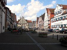
The old town centre has a highly unusual aspect; while the eastern side of the main street and market place is baroque, the western side is half timbered. From 1522 to 1731 the town was split between the protestant house of Oettingen-Oettingen and the Roman Catholic house of Oettingen-Wallerstein, which built the baroque facades. As well as one side of the street being protestant and the other side being catholic, one side used the Julian Calendar, the other side used the Gregorian Calendar. Each side also had its own synagogue.
Unlike nearby Dinkelsbühl which survived World War 2 unscathed, Oettingen was severely damaged on 23 February 1945 by an Allied bombing raid, part of Operation Clarion, in which 48 aircraft dropped some 500 boms on the town, killing 199 persons.