
Elevation 1,177 m | ||
 | ||
Similar | ||
At 1,176.6 m above sea level (NHN) the Obereck is the third highest mountain of the Central Black Forest after the Kandel and the Weißtannenhöhe. The three mountains also lie within the area designated as the High Black Forest.
Contents
Map of Obereck, 79263 Simonswald, Germany
LocationEdit
The Obereck lies in the east of the municipality of Simonswald above the village of Hintergriesbach. Its rounded summit or kuppe lies on a ridge, that is especially sharp in the area of the Schultiskopf, and which runs away from the main chain between the Rohrhardsberg and Brend descending westwards into the valley of the Wild Gutach (Simonswälder Tal) some 700 metres lower down. It is bounded by the valleys of the tributary streams, the Griesbach to the south and the Haslachsimonswälder Bach to the north (Kostgfäll Gorge).
GeologyEdit
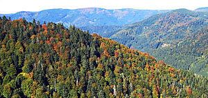
Like most of the other mountains of the Central Black Forest, the Obereck is made from gneisses. The original bunter sandstone platform was eroded away during the course of the ice ages. Traces of ice age glaciation, especially cirque-like landforms and moraines, are clearly visible on the northern slopes.
VegetationEdit
The original mixed forest stands were largely replaced by spruce as a result of intensive forestry.
TourismEdit
The Obereck is accessible on several trails, especially through the rocky, demanding climb up the arete, but is not easily linked with the nearby Kostgfäll Gorge. It is not very well known. Its heavy forestation means that the summit does not have much of a view nor are their good facilities for skiers (few pistes and no lifts). There is accommodation in the surrounding villages within Simonswald.