
Elevation 3,058 m | Last eruption 2014 | |
 | ||
Similar Mount Nyiragongo, Mount Karisimbi, Mount Mikeno, Mount Bisoke, Erta Ale | ||
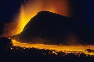
Expedition to nyamuragira kimanura eruption democratic republic of congo 2012
Nyamuragira (Derived from the Kinyarwanda verb 'Kuragira inka', meaning to herd cows; Inka means cow or cows) is an active volcano in the Virunga Mountains of the Democratic Republic of the Congo, situated about 25 km north of Lake Kivu.
Contents
- Expedition to nyamuragira kimanura eruption democratic republic of congo 2012
- Map of Nyamuragira Active Volcano Democratic Republic of the Congo
- Dr congo s nyamuragira volcano
- Geography and geology
- Sulfur dioxide
- 2010 eruption
- 2011 eruption
- 2013 activity
- 29 November 2014
- References
Map of Nyamuragira Active Volcano, Democratic Republic of the Congo
It has been described as Africa's most active volcano and has erupted over 40 times since 1885. As well as eruptions from the summit, there have been numerous eruptions from the flanks of the volcano, creating new smaller volcanoes that have lasted only for a short time (e.g. Murara from late 1976 to 1977).
Recent eruptions occurred on 2 January 2010 and 8 November 2011.
Dr congo s nyamuragira volcano
Geography and geology
Nyamuragira volcano is an active volcano in the Virunga Mountains of the Democratic Republic of the Congo, situated about 25 km north of Lake Kivu. It is in the Province of Nord-Kivu. (It is 13 km north-north-west of Nyiragongo, the volcano which caused extensive damage to the city of Goma in its 2002 eruption.)
Nyamuragira has a volume of 500 cubic km, and covers an area of 1,500 km2. It has a low shield profile, and contrasts with adjacent steep-sided Nyiragongo volcano.
Sulfur dioxide
Nyamuragira volcano is responsible for a large portion of the sulfur dioxide released into the atmosphere by volcanoes.
2010 eruption
At dawn on 2 January 2010, Nyamuragira began spewing out lava flows. There are no settlements close to the volcano, but wildlife officials feared that the eruption may threaten the chimpanzees in the area. Another danger was that the lava could have flowed into the southern sector of Virunga National Park, where there are settlements and villages.
Extensive lava flows from the 2010 eruption can be seen on satellite photographs reaching 25 km south-west to Lake Kivu, about 22 km north-west and 35 km north-north-east.
2011 eruption
The volcano erupted again on November 5, 2011.
That eruption produced a 400-meter high column of lava, and it is said to have been its largest eruption in 100 years.
2013 activity
Goma volcanologists warn for an imminent eruption, as more steam and fumes are released from the volcano.
29 November 2014
For the first time in 75 years, a new lava lake appeared at the volcano. That is one of the few volcanoes on Earth which have sustained lava lakes for several decades. The last formed lava lake at the volcano was emptied in the 1938 lava flow. The formation of the new lava lake occurred between June and August 2014. The lava lake has a depth of 500 metres. The lava lake is growing and can produce lava flows in the future. Goma vulcanologists are studying the possibilities of an evacuation in few months. The eruption wasn't that bad, but left a lot of ash and air pollution.