
Lake type oligotrophic lake Surface elevation 3,505 m Length 1.2 km | Primary inflows Surface area 1.5 km (0.58 sq mi) Area 150 ha Width 500 m | |
 | ||
Max. length 1.2 kilometres (0.75 mi) Max. width 0.5 kilometres (0.31 mi) | ||
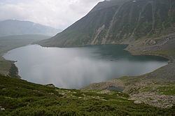
The Nundkol Lake or Nund Kol also known as Kalodaka Lake is an oligotrophic alpine lake situated in the Kashmir Valley, in Ganderbal district of Jammu and Kashmir, India.
Contents
Map of Nundkol, Forest Block 193502
Geography
The Nundkol Lake lies at the foothills of Mount Haramukh (5,142 metres (16,870 ft)). The Gangbal Lake which is bigger and at higher elevation lies 1.5 km to the north of the lake. Surrounded by the lush green meadows, the banks of the Nundkol Lake serve as the camping site during the summers. Naranag is the nearest settlement and serves as the base camp for trekking to the lake.
The Nundkol Lake is fed by Gangbal Lake and the melting glaciers of the Mount Haramukh. It gives rise to Wangath Nallah, the major right tributary of the Sind River.
Flora and fauna
During the winter, the Nundkol Lake freezes and is covered by heavy snow. In the summers, the basin of the lake is surrounded by a sheet of alpine flowers. The geum, blue poppy, potentilla and gentian are relatively common. Hedysarum flowers are found in late spring throughout the area around the lake.
The Nundkol Lake is stocked with trout among of which is the brown trout. The fishing is permitted to the licensed anglers.
Access
The Nundkol Lake is accessible only during the summer; during the winter, the treks are closed because of the heavy snowfall. It can be reached from Srinagar, via a 65 km motorable road which leads through Ganderbal and Wayil to the Naranag trekking camp. The alpine meadows of Trunakhul and Badpathri lies at the halfway point of this two-day trek to the lake. An alternate trek starts from Chattergul village, 10 km to the west of Naranag which leads through the meadows of Mahlish. The lake can also be accessed through Bandipora and the five-day trekking starting point is Arin. Tourists prefer Naranag trek and return via Gadsar Lake, Vishansar Lake and Sonamarg to cover most alpine lakes of the area.