
Headquarters Nowshera Area code(s) 0923 Population 874,373 (2014) | Time zone PST (UTC+5) Local time Tuesday 12:15 AM | |
 | ||
Weather 21°C, Wind NW at 8 km/h, 53% Humidity University Northern University Nowshera | ||
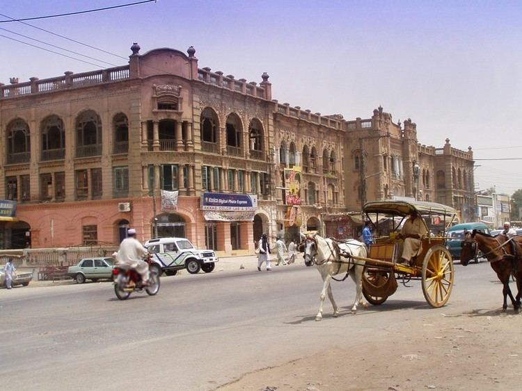
Nowshera (Pashto: نوښار) - known locally as Nowkhaar or Nowshaar is the chief city of Nowshera District in the Khyber Pakhtunkhwa Province of Pakistan. It is also one of the largest cities of the province.
Contents
- Map of Nowshera Pakistan
- Overview
- History
- Geography and climate
- Languages and demography
- Transportation
- Administrative units
- References
Map of Nowshera, Pakistan
It lies on the Kabul River, and is around 27 miles (43 km) due east of the major city of Peshawar on the Grand Trunk Road. at 34°0'55N 71°58'29E.
Overview
Nowshera city is notable for its British colonial era cantonment, which is located at 33°59'48N 72°0'47E, and is home to the Pakistan Army School of Artillery, School of ASC, ASC centre, Armour centre, Armed Forces Medical Stores Depot, and School of Armour.
The GT Road is the main road connecting villages and towns across the District. The town is also at the junction of Peshawar and Swat Roads.
History
During British rule, Nowshera was a town and cantonment as well as tehsil of the Peshawar District (later Peshawar Division). The town was on the route of the North-Western Railway and Grand Trunk Road. The population according to the 1901 census of India was 9,518.
The Imperial Gazetteer of India describes the cantonment as follows:
The cantonment stretches along the right bank of the Kābul river on a sandy plain, 3 miles in diameter, and is surrounded by low hills on all sides except the north, which is open towards the river. The garrison now consists of one British infantry regiment, two Native cavalry and four infantry regiments, a mountain battery, and a bearer corps, belonging to the Peshāwar division of the Northern Command. The Kābul river is crossed by a permanent bridge of boats, whence roads lead to Mardān and Chārsadda. The iron road and railway bridge across the river was opened on December 1, 1903. The village of Naushahra Khurd, west of the cantonment, and the large village of Naushahra Kalān, on the north bank of the Kābul, are both outside cantonment limits. The headquarters of the Naushahra tahsīl, with the police station, are in the former, 3 miles from the cantonment. The town contains a Government dispensary and a vernacular middle school, maintained by the District board.
Geography and climate
Nowshera District is bordered by Peshawar District to the west, Mardan District to the north, Charsadda District to the northwest, Swabi District to the northeast, Kohat District to the south, Orakzai Agency to the southwest, and Attock District to the east.
Generally, winters are cold from November to February, and summers are hot from June to August.
Languages and demography
Pashto language is spoken, written, and understand by the majority of residents. Hindku language is also spoken in some villages and towns. Urdu language, being the national language of Pakistan, is also spoken, written, and understood.
According to the 1998 census of Pakistan the population was 874373 persons, male population was 455598 (52.10 %), while female population was 418775 (47.90 %), a population density of 500.2 persons per km². The population of Urban dwellers was 227030 (25.96 %) and that of Rural dwellers was 647343 (74.04 %). The annual growth rate was 2.9%. The literacy rate was 89%.
Transportation
Nowshera is well connected with the rest of the Khyber Pakhtunkhwa province and other provinces of Pakistan through airports, railways, and roads. Bacha Khan International Airport in Peshawar and Benazir International Airport in Islamabad are situated at a drive of around 1 hour and 2 hours respectively. The Pakistan Railways network serves the needs of the traveling passengers and cargo shipments. The Kabul River railway station and Nowshera Junction railway station are in the city.
The National Highway 05 or the N-5 is Pakistan’s longest highway running from the port city of Karachi to the border crossing at Torkham. Its total length is 1756 km[2] and it runs north from Karachi located in Sindh province to Hyderabad, Moro and Khairpur before crossing into Punjab province where it passes through Multan, Sahiwal, Lahore, Sheikhupura District, Gujranwala, Gujrat, Jhelum and Rawalpindi. At Rawalpindi, it turns eastwards and passes through Attock Khurd before crossing the Indus River into Khyber Pakhtunkhwa to continue through Nowshera and Peshawar before entering the Khyber Pass and reaching the border town of Torkham.
The M1 is a motorway in Punjab and Khyber-Pakhtunkhwa, Pakistan. It is 155 km long, with 67 km in Punjab and the remaining 88 km in Khyber-Pakhtunkhwa. It has become a vital link to Afghanistan and Central Asia and is expected to take much traffic off the highly used N5. It is part of Pakistan’s Motorway Network. M1 begins northeast of Peshawar as it moves in an eastern direction, crossing over the Kabul River. From here it passes through Charsadda, Risalpur, Swabi and Rashakai before crossing the Indus River.
The historical Grand Trunk Road also passes through Nowshera.