
 | ||
Northeast Cay, also known as Parola Island (Tagalog: Parola; Chinese: 北子島; pinyin: Běizǐ Dǎo; Vietnamese: Đảo Song Tử Đông), with a land area of 12.7 hectares, is the fifth largest of the naturally occurring Spratly Islands and the third largest of the Philippine-occupied Spratly Islands. It is part of the North Danger Reef and is located to the northwest of Dangerous Ground.
Contents
Map of Northeast Cay
It is 1.75 miles (2.82 km) north of Vietnamese-occupied Southwest Cay (Pugad Island), and they are visible from each other. It is located 28 miles (45 km) northwest of Philippine-occupied Pag-asa (Thitu) Island. It is administered by the Philippines as part of Kalayaan, Palawan.
Parola is the Tagalog (adapted from Spanish language) word for a lighthouse.
The island is also claimed by the People's Republic of China, the Republic of China (Taiwan) and Vietnam.
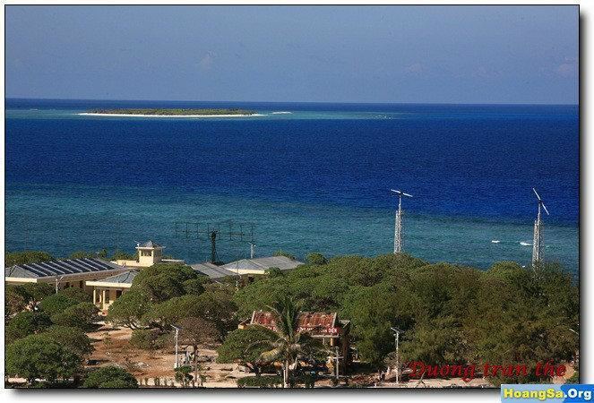
Environment
Some of Parola's outcrops are visible on its western side. It has high salinity groundwater and vegetation limited to beach type of plants. The corals around the island were mostly destroyed by rampant use of dynamite fishing and cyanide method employed by fishing boats in the past. It is covered with grass and thick trees. Much of the fringing reef is above water at high tide. It supported a beacon in 1984. It also has guano deposits.
History
In 1933, the French Government decided to take official possession of the Spratly Islands, including Northeast Cay and Southwest Cay. Three ships, the Alerte, the Astrobale and the De Lanessan, took part in the expedition.
"Further north still, at the level of Nhatrang, is the atoll named "North Danger". The Alerte took possession of two sandy islands (cayes) where it found some Japanese fishing. The De Lanessan went there too and explored the little island. The latter is perceptibly higher than the others, the highest point reaching 5 metres. The phosphate beds are considerable and were much exploited by the Japanese."After possession had been taken, the French Ministry of Foreign Affairs published the following notice:
"Notice concerning the occupation of certain islands by French naval units.The French government has caused the under mentioned isles and islets to be occupied by French naval units:The above-mentioned isles and islets henceforward come under French sovereignty. "This notice cancels the previous notice inserted in the Official Journal dated July 25, 1933, page 7784. French Journal Officiel dated July 26, 1933 (page 7837)."In 1939, Japan occupied these islands until the end of World War II.
In 1956, the French transferred these islands to South Vietnam.
In 1959, the South Vietnam Government renamed "Song Tử" (meaning twin because the two islands are very similar) with "Tây" (meaning west) and "Đông" (meaning East) to differentiate them. They were annexed to Phuoc Tuy province, South Vietnam.
On May 24, 1963, the sovereignty steles were rebuilt on Song Tu Dong (North East Cay) and Song Tu Tay (South West Cay) by crew members of the three vessels Huong Giang, Chi Lang and Ky Hoa of the South Vietnam.
In 1968, Philippines troops occupied Northeast Cay (Parola Island, Song Tu Dong) and Southwest Cay (Pugad Island, Song Tu Tay).
In 1975, Southwest Cay was reoccupied by South Vietnam (see Southwest Cay incident (1975)) and was subsequently taken over by the later unified Vietnam. The Philippines continue to occupy Northeast Cay.
Parola Island can be considered as the second top priority of the Philippines for protection, after Pagasa Island, since it is very near Vietnamese-occupied Southwest Cay (Pugad Island). There are only a few structures on this island; they serve as shelters for the soldiers.