
Area 31.81 sq mi Founded 1 April 1974 | Region North East | |
 | ||
Similar places | ||
Map of North Tyneside
The Metropolitan Borough of North Tyneside is a metropolitan borough of Tyne and Wear, in North East England, and is part of the Tyneside conurbation. The borough council's main office is at Cobalt Business Park in Wallsend. The local authority is North Tyneside Council.
Contents
- Map of North Tyneside
- Itv tyne tees northumbria healthcare newcastle united visit north tyneside general hospital
- History
- Geography
- Administration and elections
- 2013
- 2012
- Economy
- Transport
- Places of interest
- Twinned towns
- References
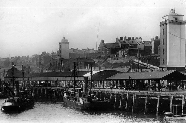
North Tyneside is bounded by Newcastle upon Tyne to the west, the North Sea to the east, the River Tyne to the south and Northumberland to the north. Within its bounds are the towns of Wallsend, North Shields, Killingworth and Whitley Bay, which form a continuously built-up area contiguous with Newcastle.
Itv tyne tees northumbria healthcare newcastle united visit north tyneside general hospital
History
The borough was formed on 1 April 1974 by the merger of the county borough of Tynemouth, with the borough of Wallsend, part of the borough of Whitley Bay, the urban district of Longbenton and part of the urban district of Seaton Valley, all of which were in Northumberland.
Geography
The following places are located in North Tyneside:
Administration and elections
Unlike most English districts, its council is led by a directly-elected mayor, currently Labour's Norma Redfearn. As of March 2016, the council is Labour led, Labour having 51 councillors, the Conservatives 7 and the Lib Dems 2.
The council is elected "in thirds", with one councillor from each three-member ward elected each year for the first three years, the mayoral election being held on the fourth year. With three councillors elected from each of 20 wards, there are 60 councillors in total.
2013
Riverside By-Election, 4 July 2013 - Labour hold
2012
Wallsend By-Election, 16 November 2012 - Liberal Democrat gain from Labour
For earlier results see North Tyneside Metropolitan Borough Council elections.
Economy
North Tyneside lies in the coalfield that covers the South-East of the historic county of Northumberland. It has traditionally been a centre of heavy industry along with the rest of Tyneside, with for example the Swan Hunter shipyard in Wallsend, and export of coal. Today most of the heavy industry has gone, leaving high unemployment in some areas (over the borough, 3.2% compared to 2.7% for the UK). The borough is the 69th most deprived in England, out of 354. However some parts function as wealthy dormitory suburbs of Newcastle, such as Tynemouth. Recent growth has come in the A19 corridor with new industrial estates and retail parks.
Transport
Two key roads serve North Tyneside:
North Tyneside is served by 17 stations on the Tyne & Wear Metro on a loop from Newcastle through Wallsend, North Shields, Whitley Bay, Benton and back to Newcastle. Trains operate at least every 15 minutes, with extra services in the peak hours. Most of the stations serving North Tyneside fall into fare zones B and C.
There are no National Rail stations in the borough, despite the East Coast Main Line and Blyth and Tyne routes passing through. The nearest National Rail station is Newcastle Central, which is also served by the Tyne and Wear Metro.
North Tyneside has an extensive bus network, with most areas benefiting from direct services to Newcastle. Many areas have direct bus services to Cramlington, Blyth or Morpeth. The principle bus operators in the area are Arriva (all areas), Go North-East (most areas) and Stagecoach in Newcastle (Benton, Forest Hall, Killingworth and Wallsend).
The Shields Ferry links North Shields to South Shields, in South Tyneside.
There is an international ferry terminal at Royal Quays in North Shields, with a service to Amsterdam (IJmuiden).