
Total islands 5 Area 72 km² Postal code 744202 Adjacent body of water Indian Ocean | Adjacent bodies of water Indian Ocean Length 7.8 km (4.85 mi) Elevation 122 m Area code 031927 | |
 | ||
Major islands North SentinelConstance Island groups Andaman Islands, Sentinel Islands | ||
North Sentinel Island is one of the Andaman Islands in the Bay of Bengal. The island belongs to the South Andaman administrative district, part of the Indian union territory of Andaman and Nicobar Islands.
Contents
- Map of North Sentinel Island Andaman and Nicobar Islands
- Must watch a banned island in india north sentinel island sentilese
- Geography
- History
- Chola dynasty
- Maratha empire
- British occupation
- Modern period
- Demographics
- Political status
- References
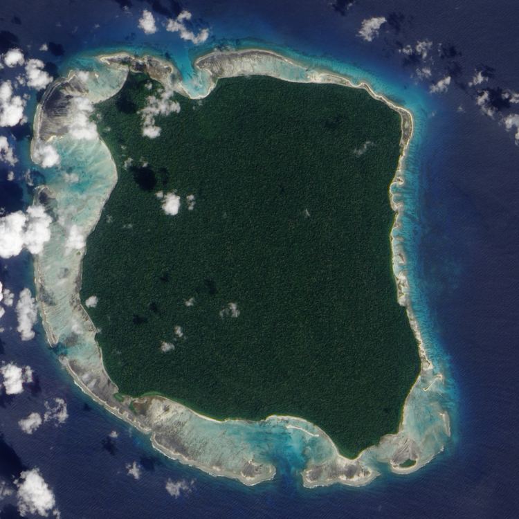
Map of North Sentinel Island, Andaman and Nicobar Islands
Must watch a banned island in india north sentinel island sentilese
Geography
North Sentinel, a part of the Sentinel Islands, lies 36 kilometres (22 mi) west of the town of Wandoor in South Andaman Island, 50 km (31 mi) west of Port Blair, and 59.6 kilometres (37.0 mi) north of its counterpart South Sentinel Island. It has an area of about 47.5 km2 (18.3 sq mi) and a roughly square outline.
North Sentinel is surrounded by coral reefs, and lacks natural harbours. The entire island, other than the reefs, is forested. There is a narrow beach encircling the island, behind which the ground rises 20 m (66 ft), and then gradually to between 46 m (150 ft) and 122 m (400 ft) near the centre. Reefs extend around the island to between 800 and 1,290 metres (0.5–0.8 mi) from the shore. A forested islet, Constance Island, also "Constance Islet", is located about 600 metres (2,000 ft) off the southeast coastline, at the edge of the reef.
The 2004 earthquake tilted the tectonic plate under the island, lifting it by 1 to 2 metres (3 to 7 ft). Large tracts of the surrounding coral reefs were exposed and became permanently dry land or shallow lagoons, extending all the island's boundaries – by as much as 1 kilometre (3,300 ft) on the west and south sides – and uniting Constance Island with the main island.
History
The Onge were aware of North Sentinel Island's existence and their traditional name for it is Chia daaKwokweyeh. They also have strong cultural similarities with what little has been remotely observed amongst the Sentinelese. However, Onge who were brought there by the British during the 19th century could not understand the language, so a significant period of separation is likely.
Chola dynasty
Rajendra Chola I (1014 to 1042 CE), one of the Tamil Chola dynasty kings, conquered the Andaman and Nicobar Islands to use them as a strategic naval base to launch a naval expedition against the Sriwijaya Empire (a Buddhist empire based in the island of Sumatra, Indonesia). They called the islands Tinmaittivu ("impure islands" in Tamil).
Maratha empire
The Andaman and Nicobar Islands as a whole provided a temporary maritime base for ships of the Maratha Empire in the 17th century. The Maratha navy's admiral Kanhoji Angre established naval supremacy with a base in the islands and is credited with attaching those islands to India.
British occupation
British surveyor John Ritchie, observed "a multitude of lights" from an East India Company hydrographic survey vessel, the Diligent, as it passed by the island in 1771. Homfray, an administrator, travelled to the island in March 1867. Toward the end of the same year's summer monsoon season, the Nineveh, an Indian merchant ship, was wrecked on a reef near the island. The 106 surviving passengers and crewmen landed on the beach in the ship's boat and fended off attacks by the Sentinelese. They were eventually found by a Royal Navy rescue party. An expedition led by Maurice Vidal Portman, a government administrator who hoped to research the natives and their customs, accomplished a successful landing on North Sentinel Island in January 1880. The group found a network of pathways and several small, abandoned villages. After several days, six Sentinelese (an elderly couple and four children) were captured and taken to Port Blair. The colonial officer in charge of the kidnapping wrote that the entire group, "sickened rapidly, and the old man and his wife died, so the four children were sent back to their home with quantities of presents". A second landing was made by Portman on 27 August 1883 after the eruption of Krakatoa was mistaken for gunfire and interpreted as the distress signal of a ship. A search party landed on the island and left gifts before returning to Port Blair. Portman visited the island several more times between January 1885 and January 1887.
Modern period
Indian exploratory parties under orders to establish friendly relations with the Sentinelese made brief landings on the island every few years beginning in 1967. In 1975, Leopold III of Belgium, on a tour of the Andamans, was brought by local dignitaries for an overnight cruise to the waters off North Sentinel Island. The cargo ships MV Rusley and MV Primrose ran aground on coastal reefs in mid-1977 and August 1981 respectively. The Sentinelese are known to have scavenged these wrecks for iron. Settlers from Port Blair also visited the sites to recover cargo. In 1991, salvage operators were authorised to dismantle the ships.
On 2 August 1981, the ship Primrose grounded on the North Sentinel Island reef. A few days later, crewmen on the immobile vessel observed that small black men were carrying spears and arrows and building boats on the beach. The captain of Primrose radioed for an urgent drop of firearms so the crew could defend themselves, but did not receive them due to a large storm stopping vessels from reaching them. Heavy seas kept the islanders away from the ship. After a week, the crew were rescued by a helicopter working under contract to the Indian Oil And Natural Gas Corporation (ONGC).
The first peaceful contact with the Sentinelese was made by Triloknath Pandit, a director of the Anthropological Survey of India, and his colleagues on 4 January 1991. Indian visits to the island ceased in 1997.
The Sentinelese survived the 2004 Indian Ocean earthquake and its after-effects, including the tsunami and the uplifting of the island. Three days after the event, an Indian government helicopter observed several of them, who shot arrows and threw stones at the hovering aircraft. Although the tsunami disturbed the fishing grounds of the Sentinelese, they appear to have adapted.
On 26 January 2006, two fishermen were killed by Sentinelese when their boat drifted near the island.
Demographics
A group of indigenous people, the Sentinelese, live on North Sentinel Island. Their population is estimated to range from 50 to 400 individuals. The Sentinelese reject any contact with other people, and are among the last people to remain virtually untouched by modern civilisation. The population faces the potential threats of infectious diseases to which they have no immunity, as well as violence from intruders. The Indian government has thus declared the entire island and its surrounding waters extending 3 nautical miles (5.6 kilometres) from the island, to be an exclusion zone. At the 2011 census, the India surveyors counted 15 natives on the shore of the island.
Political status
The Andaman and Nicobar Administration has stated in 2005 that they have no intention to interfere with the lifestyle or habitat of the Sentinelese and are not interested in pursuing any further contact with them. North Sentinel Island is not legally an autonomous administrative division of India. However, scholars have referred to it and its people as autonomous, or "independent."