
Country United States County Lorain Time zone Eastern (EST) (UTC-5) Zip code 44039 Population 31,269 (2013) | State Ohio Elevation 728 ft (222 m) ZIP codes 44039 Local time Sunday 5:55 AM Area code 440 | |
 | ||
Weather 1°C, Wind NW at 13 km/h, 89% Humidity | ||
North Ridgeville is a city located along the eastern border of Lorain County, Ohio, United States. The city's population was 29,465 at the 2010 census. A west side suburb of Cleveland, North Ridgeville was the fastest-growing city in the entire Greater Cleveland area.
Contents
- Map of North Ridgeville OH USA
- History
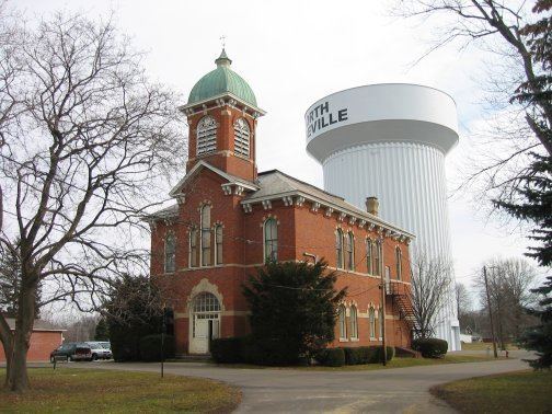
- On the National Register of Historic Places
- Geography
- Metropolitan Area
- Zip code
- Area code
- 2000 census
- 2010 census
- Public schools
- Private schools
- College and universities
- Transportation
- Corn Festival
- Shopping
- Parks and recreation
- Notable people
- References
Map of North Ridgeville, OH, USA
Located 8 miles (13,000 m) from Cleveland Hopkins International Airport, and 18 miles (29,000 m) west of downtown Cleveland. North Ridgeville is the third-largest city in Lorain County, and the 45th most-populated city in Ohio.
History
The first settlement of what is now North Ridgeville was made in 1810. The village was named for a ridge near the original town site.
On the National Register of Historic Places
Geography
North Ridgeville is located in North East Ohio at 41°23′22″N 82°0′17″W (41.389546, -82.004605).
According to the United States Census Bureau, the city has an area of 23.58 square miles (61.07 km2), of which 23.44 square miles (60.71 km2) is land and 0.14 square miles (0.36 km2) is water.
Located in eastern Lorain County, it borders the following municipalities and townships:
Metropolitan Area
North Ridgeville, is a part of the Cleveland-Elyria-Mentor Metropolitan Statistical Area which in 2010 had a population of 2,077,240. North Ridgeville is also part of the larger Cleveland-Akron-Elyria Combined Statistical Area, which in 2010 had a population of 2,780,440.
Zip code
The city of North Ridgeville has a post office, with the zip code of 44039. This zip code covers most of the city. Some sections of the city use zip codes 44035, 44011 and 44044. And in the 2000s, zip code 44039 was expanded outside of the city limits along highway 10 into Eaton, and Carlisle Townships.
Area code
In the 1950s, AT&T assigned North Ridgeville, and Northeast Ohio the 216 area code. In 1996, Northeast Ohio was divided into two area codes. Area code 216 was reduced in size to cover the northern half of its prior area, centering on Cleveland and its lake shore suburbs. Area code 330 was introduced for remaining outlying areas formerly covered by area code 216, including Akron, Brunswick, Canton, Medina, Warren and Youngstown.
2000 census
As of the census of 2000, there were 22,338 people, 8,356 households, and 6,434 families residing in the city. The population density was 369.1/km² (955.8/mi²). There were 8,587 housing units at an average density of 141.9/km² (367.4/mi²). The racial makeup of the city was 96.36% White, 0.86% African American, 0.21% Native American, 0.92% Asian, 0.49% from other races, and 1.15% from two or more races. Hispanic or Latino of any race were 1.99% of the population.
There were 8,356 households out of which 32.9% had children under the age of 18 living with them, 65.1% were married couples living together, 8.5% had a female householder with no husband present, and 23.0% were non-families. 19.4% of all households were made up of individuals and 6.5% had someone living alone who was 65 years of age or older. The average household size was 2.65 and the average family size was 3.05.
In the city the population was spread out with 24.4% under the age of 18, 7.0% from 18 to 24, 30.6% from 25 to 44, 27.3% from 45 to 64, and 10.7% who were 65 years of age or older. The median age was 38 years. For every 100 females there were 96.4 males. For every 100 females age 18 and over, there were 93.6 males.
The median income for a household in the city was $54,482, and the median income for a family was $61,621. Males had a median income of $42,634 versus $27,379 for females. The per capita income for the city was $22,971. About 2.3% of families and 3.2% of the population were below the poverty line, including 4.2% of those under age 18 and 5.0% of those age 65 or over.
2010 census
As of the census of 2010, there were 29,465 people, 11,500 households, and 8,486 families residing in the city. The population density was 1,257.0 inhabitants per square mile (485.3/km2). There were 12,109 housing units at an average density of 516.6 per square mile (199.5/km2). The racial makeup of the city was 95.0% White, 1.5% African American, 0.2% Native American, 1.2% Asian, 0.6% from other races, and 1.6% from two or more races. Hispanic or Latino of any race were 3.3% of the population.
There were 11,500 households of which 32.1% had children under the age of 18 living with them, 61.3% were married couples living together, 8.6% had a female householder with no husband present, 3.9% had a male householder with no wife present, and 26.2% were non-families. 21.9% of all households were made up of individuals and 8.4% had someone living alone who was 65 years of age or older. The average household size was 2.54 and the average family size was 2.97.
The median age in the city was 40.7 years. 23.1% of residents were under the age of 18; 5.9% were between the ages of 18 and 24; 27.1% were from 25 to 44; 28.9% were from 45 to 64; and 15% were 65 years of age or older. The gender makeup of the city was 49.1% male and 50.9% female.
Public schools
The North Ridgeville City School District is managed by a directly-elected school board. The North Ridgeville City School District was given a mediocre report card by the Ohio Department of Education for the years 2015-16. It had a grade of F for "Gap Closing" as well as "K-3 Literacy", while receiving a B for "Graduation Rate".
Public elementary schools include:
Public middle schools include:
Public high schools include:
North Ridgeville High School was named Ohio Lottery School of the Year for 2009-2010, and 2012-2013.
In November 2013, the citizens of North Ridgeville passed a bond issue for the replacement of the North Ridgeville Middle School, Elizabeth Wilcox Elementary, and the Rangers Stadium. In late 2014, the new Ranger's Stadium is schedule for completion, just in time for the Rangers to switch conferences to the Southwestern Conference, whose members include Avon Lake, Amherst, North Olmsted and Westlake. The new school for grades 3-8, and the new stadium will be constructed on the property adjacent to the current North Ridgeville High School, on Bainbridge Road. The old schools, and stadium are scheduled for demolition once the new facilities are completed, and open. Also the district will be rearranging preexisting schools taking Early Childhood Learning Center out of commission, while replacing the roof on Liberty School.
Private schools
Private schools include:
College and universities
College and universities located in and around North Ridgeville, Ohio.
Transportation
North Ridgeville is served by many highways, including I-80 (Ohio Turnpike), the Outerbelt South Freeway Interstate 480 (Ohio), U.S. Route 20, Ohio State Route 10, Ohio State Route 83, and Ohio State Route 113. And just minutes away from I-90, and Ohio State Route 2.
The airport for North Ridgeville is the Cleveland Hopkins International Airport (located in Cleveland, Ohio), and the Lorain County Regional Airport is the nearest county airport.
The Elyria, and Cleveland Amtrak Stations provide train transportation to the residents of North Ridgeville.
Corn Festival
In the June 2002 issue of Cleveland Magazine, the North Ridgeville Corn Festival was voted the best festival in Northeast Ohio.
North Ridgeville is home to the North Ridgeville Corn Festival. The history started when the Bicentennial Committee for the City of North Ridgeville was formed in 1975 to celebrate the upcoming United States bicentennial in 1976. The first festival ran 6 hours and featured 13 booths around the North Ridgeville Middle School track. The proceeds were donated to the library to assist with the cost of relocating it from the old Lawson’s store area the Olde Town Hall building across the street. The next year, in 1976, in addition to celebrating the bicentennial, the festival was held in honor Harold Sweet, a sweet corn grower in North Ridgeville, for all that he did for the youth and citizens of the city. The proceeds from this festival were donated to purchase trees for the then new Bainbridge Extension along with 2 bicentennial flags for City Hall. The Bicentennial Committee was renamed the North Ridgeville Corn Festival Committee in 1977.