
ZIP codes 69101, 69103 Elevation 854 m Population 24,534 (2013) | State Nebraska Time zone Central (CST) (UTC-6) Area code(s) 308 Local time Sunday 4:26 AM | |
 | ||
Weather 12°C, Wind SE at 10 km/h, 67% Humidity Colleges and Universities Mid-Plains Community College, North Platte Community College | ||
Find scrub stores in north platte nebraska
North Platte is a city in and the county seat of Lincoln County, Nebraska, United States. It is located in the southwestern part of the state, along Interstate 80, at the confluence of the North and South Platte Rivers forming the Platte River. The population was 24,733 at the 2010 census.
Contents
- Find scrub stores in north platte nebraska
- Map of North Platte NE 69101 USA
- History
- Geography
- Climate
- 2010 census
- 2000 census
- Points of interest
- Notable people
- References
Map of North Platte, NE 69101, USA
North Platte is a railroad town; Union Pacific Railroad's large Bailey Yard is located within the city. Today, North Platte is served only by freight trains, but during World War II the city was famous for the North Platte Canteen. Tens of thousands of volunteers from North Platte and surrounding towns met the troop trains passing through North Platte, offering coffee, sandwiches and hospitality.
North Platte is the principal city of the North Platte Micropolitan Statistical Area, which includes Lincoln, Logan, and McPherson counties.
History
North Platte was established in 1868 when the Union Pacific Railroad was extended to that point. It was named from the North Platte River.
Geography
North Platte is located at 41°8′9″N 100°46′14″W (41.135914, −100.770501). According to the United States Census Bureau, the city has a total area of 13.39 square miles (34.68 km2), of which, 13.20 square miles (34.19 km2) is land and 0.19 square miles (0.49 km2) is water.
Climate
North Platte experiences a dry continental climate similar to that of the Nebraska High Plains, classified as humid continental (Köppen Dwa), and, with an annual average precipitation of 20.22 inches (514 mm), barely avoids semi-arid; it is part of USDA Hardiness zone 5a. The normal monthly mean temperature ranges from 25.0 °F (−3.9 °C) in January to 74.3 °F (23.5 °C) in July. On average, there are 3.5 days that reach 100 °F (38 °C) or higher, 37 days that reach 90 °F (32 °C) or higher, 33 days that do not climb above freezing, and 13 days with a low of 0 °F (−18 °C) or below. The average window for freezing temperatures is September 26 thru May 10, allowing a growing season of 138 days. Extreme temperatures officially range from −35 °F (−37 °C) on January 15, 1888 and February 12, 1899, up to 112 °F (44 °C) on July 11, 1954; the record cold daily maximum is −15 °F (−26 °C) on January 14, 1888, while, conversely, the record warm daily minimum is 80 °F (27 °C) on July 25, 1940.
Precipitation is greatest in May and June and has ranged from 10.01 in (254 mm) in 1931 to 33.44 in (849 mm) in 1951. Snowfall averages 28.5 in (72 cm) per season, and has historically ranged from 3.0 in (7.6 cm) in 1903–04 to 66.3 in (168 cm) in 1979–80; the average window for measurable (≥0.1 in or 0.25 cm) snowfall is October 30 thru April 11, with May snow being rare.
2010 census
As of the census of 2010, there were 24,733 people, 10,560 households, and 6,290 families residing in the city. The population density was 1,873.7 inhabitants per square mile (723.4/km2). There were 11,450 housing units at an average density of 867.4 per square mile (334.9/km2). The racial makeup of the city was 93.1% White, 1.0% African American, 0.7% Native American, 0.7% Asian, 2.8% from other races, and 1.7% from two or more races. Hispanic or Latino of any race were 8.8% of the population.
There were 10,560 households of which 30.4% had children under the age of 18 living with them, 44.5% were married couples living together, 10.7% had a female householder with no husband present, 4.3% had a male householder with no wife present, and 40.4% were non-families. 34.8% of all households were made up of individuals and 13.9% had someone living alone who was 65 years of age or older. The average household size was 2.29 and the average family size was 2.95.
The median age in the city was 37.1 years. 24.9% of residents were under the age of 18; 9% were between the ages of 18 and 24; 25% were from 25 to 44; 25.6% were from 45 to 64; and 15.5% were 65 years of age or older. The gender makeup of the city was 48.8% male and 51.2% female.
2000 census
As of the census of 2000, there were 23,878 people, 9,944 households, and 6,224 families residing in the city. The population density was 2,281.5 people per square mile (880.5/km²). There were 10,718 housing units at an average density of 1,024.1 per square mile (395.2/km²). The racial makeup of the city was 93.47% White, 0.71% African American, 0.64% Native American, 0.39% Asian, 0.03% Pacific Islander, 3.30% from other races, and 1.45% from two or more races. Hispanic or Latino of any race were 6.68% of the population.
There were 9,944 households out of which 31.0% had children under the age of 18 living with them, 49.8% were married couples living together, 9.6% had a female householder with no husband present, and 37.4% were non-families. 31.9% of all households were made up of individuals and 13.0% had someone living alone who was 65 years of age or older. The average household size was 2.34 and the average family size was 2.97.
In the city, the population was spread out with 26.0% under the age of 18, 9.5% from 18 to 24, 26.8% from 25 to 44, 21.9% from 45 to 64, and 15.8% who were 65 years of age or older. The median age was 36 years. For every 100 females there were 94.5 males. For every 100 females age 18 and over, there were 90.0 males.
As of 2000 the median income for a household in the city was $34,181, and the median income for a family was $42,753. Males had a median income of $36,445 versus $20,157 for females. The per capita income for the city was $18,306. About 7.8% of families and 10.5% of the population were below the poverty line, including 13.2% of those under age 18 and 9.8% of those age 65 or over.
Points of interest
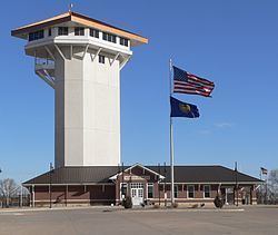
North Platte is home to the world's largest rail yard, Bailey Yard. The Golden Spike Tower and Visitor Center is an eight-story building which overlooks the expansive railroad staging area. The tower and visitor center are open to the public year-round.
North Platte was the western terminus of the Union Pacific Railway from the summer of 1867 until the next section to Laramie, Wyoming, was opened the following summer. Even though Congress had authorized the building of the Transcontinental Railroad in 1862, it was only extended as far as Nebraska City by the start of the summer of 1867. The 275-mile section from Nebraska City to North Platte was completed in less than six weeks.
Lincoln County Historical Museum contains a display detailing the history of the North Platte Canteen, which greeted 6.5 million service personnel from Christmas Day 1941 through April 1, 1946. It also contains a Prairie Village with local landmark homes and other buildings, including a Pony Express station and pioneer church among many others.
Buffalo Bill Ranch State Historical Park is located near North Platte, a Nebraska living history park about Buffalo Bill Cody. The park includes his actual house known as Scout's Rest Ranch. The park is two miles west of U.S. Highway 83 along U.S. Highway 30.
Every June, North Platte hosts the annual "Nebraskaland Days". The event includes parades, art shows, rodeos, concerts, and food events. It draws over 100,000 attendees every year.
North Platte is host to the annual Miss Nebraska pageant, an official preliminary for the Miss America Organization.