
Existed: 1927–1928 – present | Length 86.7 km | |
 | ||
Counties | ||
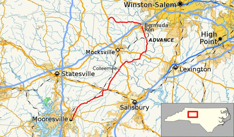
North Carolina Highway 801 (NC 801) is a primary state highway in the state of North Carolina. The highway runs north–south, traversing the central Piedmont region of the state.
Contents
Map of NC-801, North Carolina, USA
Route description
A two-lane rural highway, it traverses 53.9 miles (86.7 km) from Mooresville to U.S. Route 601 (US 601) near Farmington. It links several small towns and communities including Cooleemee, Advance, and Bermuda Run.
History
NC 801 was first commissioned in 1927–28 as a short route traveling east–west from to NC 65 (now US 158) at the now-defunct town of Hillsdale. The route was extended south from its eastern terminus to connect with NC 90 (now US 64) by 1930, becoming a north–south route. In 1933, the route was extended again, from NC 90 southewest to Mooresville, replacing all of NC 803, which ran from US 601 south of Mocksville to NC 26 (now US 29) in Mooresville. Between 1934 and 1936, NC 801 was rerouted in the Hillsdale area, eliminating a concurrency with US 158. In the early 1950s, another short concurrency, with US 64, was replaced with a continuous alignment. When US 70 was shifted onto a new alignment, so did the NC 801 concurrency between 1956 and 1958.
NC 803
North Carolina Highway 803 (NC 803) was established as a new primary routing in 1931 as a spur of NC 80 (now US 601) to Cooleemee. In 1932 it was extended southwest through Barber to NC 150 (now NC 152) in Mooresville. In 1933, it was replaced by an extension of NC 801.