
Existed: 1921 – present Length 69.4 km | Constructed 1921 | |
 | ||
Counties | ||
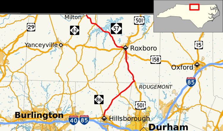
North Carolina Highway 57 (NC 57) is a 43-mile-long (69 km) North Carolina state highway and a semi-rural traffic artery connecting Roxboro to a few small-to-medium-sized towns in the The Triangle region north of the cities of Durham and Chapel Hill.
Contents
Map of NC-57, North Carolina, USA
Route description
The northern terminus of NC 57 begins at NC 62 near the Dan River in the border town of Milton, just shy of the Virginia state line. From there, the highway travels through the center of town and southeast to Roxboro. NC 57 merges with US 158 and NC 49 in Roxboro and continues east to US 501 (North Madison Boulevard) just west of downtown. At that point, US 158 and NC 57 turn right to follow US 501 through the southern section of Roxboro, passing the northern terminus of NC 157. US 158 breaks off just past that junction and heads east to Oxford while US 501 and NC 57 continue southward towards Durham.
The two highways remain concurrent almost to the Durham County line where NC 57 turns right before Rougemont and crosses into Orange County on its way to Hillsborough where the highway ends at NC 86 just north of town.
NC 57 has three highway concurrencies along its route. These include US 158 for 1.4 miles (2.3 km) in Roxboro, NC 49 for 0.4 miles (0.64 km) in Roxboro, and US 501 for 10.8 miles (17.4 km) between Rougemont and Roxboro.
History
During the 1920s, NC 57 originally ran east–west from Roxboro to Henderson along present day US 158. By 1940, the highway was changed to its current route.