
Existed: 1934 – present Constructed 1934 | Length 95.4 km | |
 | ||
Counties Moore County, North Carolina | ||
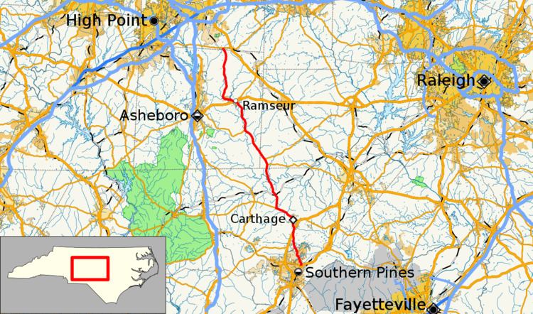
North Carolina Highway 22 (NC 22) is a North Carolina state highway that runs in the central-north part of the state. It runs between Southern Pines and Climax. The route is signed north–south, and is 59 miles (95 km) in length.
Contents
- Map of NC 22 North Carolina USA
- Route description
- Nearby landmarks
- Original NC 22
- Current route
- References
Map of NC-22, North Carolina, USA
Route description
The route's northern terminus is in the community of Climax at NC 62 in Guilford County. Shortly after beginning, the route crosses into Randolph County. Running southward as a two-lane road, NC 22 goes through the town of Franklinville and enters Ramseur, where it meets US 64/NC 49. Continuing south out of Ramseur, NC 22 joins NC 42 in the small community of Coleridge. The dual numbered road then continues southeasterly through the community of Bennett in Chatham County where it meets a terminus of NC 902. Shortly after, NC 22 splits from NC 42 and runs south into Moore County.
After crossing the Deep River, NC 22 meets NC 24/NC 27. From that intersection, the three routes become cosigned for a five-mile (8 km) stretch into Carthage. NC 22 splits from NC 24 and NC 27 in Carthage after looping around the Moore County courthouse. Exiting Carthage as McNeill Street, NC 22 joins US 15/501 for a one-mile (1.6 km) stretch before running independently to its southern terminus at NC 2 in Southern Pines. The route ends just shy of NC 2's interchange with U.S. 1.