
Existed: By 1924 – present Length 92.9 km | North end: SR 395 near Poplar | |
 | ||
Counties | ||
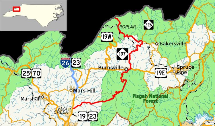
North Carolina Highway 197 (NC 197) is a north/south state highway in Western North Carolina. The route is approximately 58 miles (93 km) in length and with its continuation into Tennessee as SR 395 connects Erwin, Tennessee to Flat Creek, North Carolina. Portions of this highway lie within the Pisgah National Forest and is one of the few highways in the state with an unpaved portion.
Contents
Map of NC-197, North Carolina, USA
Mitchell County
Beginning at the state line with Tennessee, NC 197 enters the Pisgah National Forest and winds south down the Unaka escarpment to Poplar. South of Poplar, NC 197 begins the first of three segments where it follows the North Toe River and the former Clinchfield Railroad. It intersects and overlaps NC 226 for a short distance near Red Hill.
Yancey County
The final segment of NC 197 that follows the Toe River does so in the reverse direction as the previous two times this occurred. This segment comes after a railroad crossing and a new concrete arch bridge that carries the highway across the Toe River into Yancey County.
After leaving the river area, NC 197 continues through mountains and grassy knolls until it arrives at U.S. Route 19E (US 19E) just east of Burnsville.
Following a short overlap with US 19E, NC 197 leaves US 19E in Burnsville as Pensacola Road and goes through the Cane River valley to Pensacola. From Pensacola, NC 197 turns right and proceeds over Cane River Gap into Buncombe County after passing through Murchison.
Buncombe County
As it enters Buncombe County, NC 197 (now North Fork Road) turns to gravel as it crosses the Cane River Gap for a short distance and reenters the Pisgah National Forest for a short distance. As it winds its way down to the Barnardsville valley it crosses over the headwaters of Ivy Creek four times before it continues onto the pavement near Barnardsville.
From Barnardsville, NC 197 (as the Barnardsville Highway) becomes a relatively straight road that partially follows Ivy Creek until its junction with Future Interstate 26/US 19/US 23 at exit 15 near Flat Creek. Proceeding forward from the end of NC 197 is Jupiter Road (SR 1756).
A right turn before the overpass allows access to west I-26/north US 19/US 23 to Johnson City, Tennessee. A left turn after the I-26 underpass allows access to east I-26/south US 19/US 23 to Asheville.
History
From the 1920s-1940s, NC 197 was formed, running from Cane Creek Post Office (near Burnsville) to Bakersville. Portions of that alignment are now NC 226. Between 1924 and 1948 the highway's route had been changed to run from the former NC 26 at Red Hill southward to Flat Creek along a route similar to that in use today. In the 1980s, NC 197 is extended from Red Hill to the Tennessee state line where it enters Tennessee as TN 395.