
Country United States Founded 1876 Elevation 510 m Population 6,073 (2013) | State Tennessee Settled 1780s Incorporated 1903 Zip code 37650 Local time Tuesday 1:04 PM | |
 | ||
Weather 18°C, Wind S at 21 km/h, 52% Humidity | ||
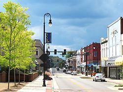
Erwin is a town in and the county seat of Unicoi County, Tennessee, United States. The population was 6,097 at the 2010 census. It is part of the Johnson City Metropolitan Statistical Area, which is a component of the Johnson City–Kingsport–Bristol, TN-VA Combined Statistical Area – commonly known as the "Tri-Cities" region.
Contents
Map of Erwin, TN 37650, USA
History
The town of Erwin received its name by a mail mishap. On December 5, 1879, the name of the town was Ervin, in honor of D.J.N. Ervin, who had donated 15 acres (61,000 m2) of land for the county seat. A typo made by post office officials caused the name to be recorded as Erwin. The mistake was never corrected.
Erwin earned some notoriety in 1916 when the only known public execution of an elephant in Tennessee occurred in the community. Mary, the elephant, had killed her handler, Wallter Eldridge, in nearby Kingsport. As home to the region's largest railway yard, Erwin was the only community with the means to carry out the death sentence. Surrounding communities decided that Erwin was the best place to carry out the execution and Erwin obliged, even though the town itself was against it. An estimated 2,500 people turned out at the local railway yard to see Mary hoisted by a crane to meet her demise. The town has recently implemented a yearly festival to help raise funds that go exclusively to the Elephant Sanctuary in Hohenwald, TN.
Between 1916 and 1957, the Southern Potteries plant operated in Erwin along Ohio Avenue. The plant produced a hand-painted dishware known as Blue Ridge that became popular nationwide in late 1930s and 1940s. Blue Ridge pieces are still popular items with collectors of antique dishware.
Geography
Erwin is located at 36°8′42″N 82°24′39″W (36.145036, -82.410796), The town is situated in a valley at the confluence of North Indian Creek, which approaches from the northeast, and the Nolichucky River, which enters the valley from the mountains to the southeast. Just before reaching Erwin, the Nolichucky passes through a narrow gorge popular with whitewater rafters.
Erwin is surrounded by the Cherokee National Forest, and mountains dominate the view in all directions. Buffalo Mountain rises to the north, Rich Mountain rises to the west, and the Unaka Mountains rise to the south and east.
The Appalachian Trail passes east of Erwin. The trail crosses the Nolichucky near the western end of the Nolichucky Gorge, at a place known as Unaka Springs. Nearby is "Moaning Rock", a large boulder near the trail that is supposed to be the site of a long ago murder of a stranger. According to local lore, the murdered man's spirit is still around, and if anyone stands on or even touches the rock, "...it moans as if under a heavy burden."
Interstate 26 passes through western and southern Erwin. Tennessee State Route 107 (North Main Avenue) connects Erwin to Unicoi to the north and the Embreeville area and Washington County to the west. Tennessee State Route 395 connects Erwin with the rural parts of Mitchell and Yancey counties to the east in North Carolina, crossing the Unakas at the 3,100-foot (940 m) Indian Grave Gap (the road becomes North Carolina Highway 197 at the state line).
According to the United States Census Bureau, the city has a total area of 3.5 square miles (9.1 km2), of which 3.5 square miles (9.1 km2) is land and 0.28% is water.
Demographics
As of the census of 2000, there were 5,610 people, 2,470 households, and 1,588 families residing in the city. The population density was 1,582.8 people per square mile (611.9/km²). There were 2,645 housing units at an average density of 746.2 per square mile (288.5/km²). The racial makeup of the city was 97.77% White, 0.05% African American, 0.29% Native American, 0.11% Asian, 1.02% from other races, and 0.77% from two or more races. Hispanic or Latino of any race were 2.00% of the population.
There were 2,470 households out of which 23.4% had children under the age of 18 living with them, 50.6% were married couples living together, 10.9% had a female householder with no husband present, and 35.7% were non-families. 33.6% of all households were made up of individuals and 18.3% had someone living alone who was 65 years of age or older. The average household size was 2.21 and the average family size was 2.80.
In the city the population was spread out with 19.7% under the age of 18, 6.8% from 18 to 24, 25.5% from 25 to 44, 25.1% from 45 to 64, and 22.9% who were 65 years of age or older. The median age was 44 years. For every 100 females there were 86.3 males. For every 100 females there were 82.3 males.
The median income for a household in the city was $29,644, and the median income for a family was $37,813. Males had a median income of $31,894 versus $20,118 for females. The per capita income for the city was $15,868. About 7.5% of families and 13.0% of the population were below the poverty line, including 20.7% of those under age 18 and 8.2% of those age 65 or over.
Economy and culture
Nuclear Fuel Services has a major facility in Erwin. It began operation in 1957 as the Davison Chemical Division of the W.R. Grace Company. Production activities at the Erwin facility include preparing enriched uranium to be processed into nuclear reactor fuel, processing uranium hexafluoride into other uranium compounds, and downblending high-enriched uranium to convert it to a low-enriched form for use in commercial nuclear reactors. Historically the facility also worked with thorium compounds.
Erwin was host to a CSX rail yard, diesel shop, and car repair facility, which closed in 2015.