
Existed: 1962 – present Constructed 1962 | Length 75 km | |
 | ||
North end: NC 210 in Bells Crossroads Counties | ||
North Carolina Highway 133 (NC 133) is a primary state highway in the U.S. state of North Carolina. The road goes through historic downtown Wilmington and near Military Ocean Terminal Sunny Point.
Contents
Map of NC-133, North Carolina, USA
Route description
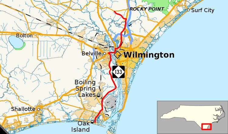
NC 133 starts at the intersection of East Oak Island Drive and Country Club Drive in downtown Oak Island. The start of the road is just about one-half mile (0.80 km) from the Oak Island lighthouse, a tourist attraction in the area. NC 133 crosses the Intracoastal Waterway shortly after its southern terminus and crosses the waterway on an elevated road bridge. The road then turns into Long Beach Road SE and passes the Cape Fear Regional Jetport. Then about 2.1 miles (3.4 km) later it passes NC 211 (Southport-Supply Rd SE). NC 133 continues on Long Beach Road Extension for 1.7 miles (2.7 km). It runs concurrently with NC 87 (River Rd SE) for one mile (1.6 km). Near Boiling Spring Lakes, NC 133 bears right from NC 87 and goes toward Wilmington. The border of Military Ocean Terminal Sunny Point coincides with the right side of the road (heading north) in this area. NC 133 goes along the side of Boiling Spring Lakes but never goes into the town. Past Boiling Spring Lakes the road goes through a lot of marshy grassland alongside of the Cape Fear River. The road passes over Town Creek. Passing through Belville, NC 133 encounters a historic marker dedicated to Robert Howe. In Leland the road merges with U.S. Route 17 (US 17), US 74, and US 76 to go over the Brunswick River.
After going over the Brunswick River, NC 133 heads north again along with US 17, US 74, and US 421 at a trumpet interchange while US 17 Business, US 76, and US 421 south cross into downtown Wilmington via the Cape Fear Memorial Bridge. An intersection north of the trumpet interchange provides access to the USS North Carolina Battleship Memorial. The three routes pass over the Cape Fear River on the S. Thomas Rhodes Bridge. US 74 and NC 133 turn east from the north-south road and cross the Northeast Cape Fear River via the Isabel Holmes Bridge. After an interchange with 3rd Street, the roads run concurrently along the Martin Luther King Jr. Parkway until NC 133 exits off the freeway at Castle Hayne Road. The road goes through Wrightsboro, a small town north of downtown Wilmington. NC 133 then meets Interstate 140 and US 17. The highway has an interchange with on and off ramps going to the freeway. NC 133 meets up with US 117 and NC 132 near Skippers Corner, also a small township north of Wilmington. NC 132 ends to the right of the intersection and NC 133 turns left to run with US 117. NC 133 and US 117 both run through downtown Castle Hayne. NC 133 turns left at Old Blossom Ferry Road. NC 133 ends at an intersection with NC 210 near Castle Hayne.
North Carolina Bicycle Route 5 is concurrent along NC 133 from the northernmost US 17 / US 421 intersection, across the Isabel Holmes Bridge, to Third Street in Wilmington.
History
Established in 1962 as a renumbering of NC 40, from Oak Island to NC 210, at Bells Crossroads. The route has been adjusted over the years as various sections from Belville to and through Wilmington onto freeways. Its biggest adjustment was in December, 2005 when NC 133 was deleted from a section North Front Street, North Fourth Street and Cornelius Harnett Street, creating a gap in the route; it was reestablished in February, 2008 via Martin Luther King Jr. Parkway.
In 2014, construction began on the 2.2-mile-long (3.5 km) Long Beach Road Extension in Brunswick County which removed NC 133 from a concurrency with NC 211 and shortened it concurrency with NC 87. The project was completed on January 10, 2016.
North Carolina Highway 40
The third and final NC 40 that appeared in North Carolina was established in 1957 as a new primary routing, with several multiplexes, from near Southport to Bells Crossroads. By 1960, it was extended southeast to Yaupon Beach, on Oak Island. By 1962, because of the establishment of I-40, NC 40 was renumbered to NC 133.