
Existed: 1921 – present Constructed 1921 | West end: NC 226 in Polkville Length 77.7 km | |
 | ||
Counties | ||
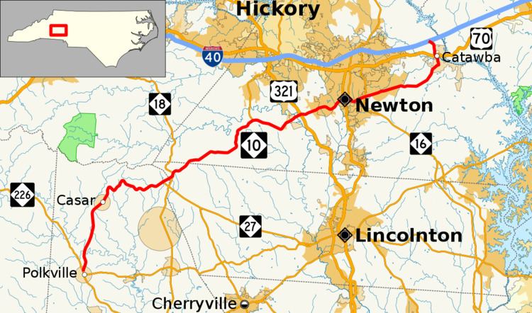
North Carolina Highway 10 (NC 10) is a primary state highway in the U.S. state of North Carolina. Originally established as the state's central highway, from Murphy to Beaufort. Nowadays, it serves to connect the city of Newton with the nearby communities and towns in the foothills region.
Contents
- Map of W North Carolina 10 North Carolina USA
- Catawba County
- Lincoln County
- Cleveland County
- History
- ConoverCatawba alternate route
- High Point alternate route
- GibsonvilleBurlington alternate route
- References
Map of W North Carolina 10, North Carolina, USA
Catawba County
NC 10's eastern terminus is at Interstate 40 (exit 138) in Catawba County, just southwest of Statesville and just northeast from Claremont. From this point, NC 10 travels in a southerly (signed west) direction as Oxford School Road, crossing US 70 and entering the town of Catawba. As Main Street, NC 10 travels through the heart of the town and turns right on Second Avenue. Exiting the town to the southwest, NC 10 travels to the city of Newton where it merges with NC 16 for a short while and takes the name of D Street, and later C Street. After leaving Newton, NC 10 has an interchange with the US 321 freeway and meets a terminus of NC 127 before crossing the county line.
Lincoln County
After NC 10 enters Lincoln County, it meets NC 18 in the community of Laurel Hill. NC 18 and NC 10 are concurrent for about a one-mile (1.6 km) stretch before NC 10 splits in a westerly direction. The route then crosses another county line.
Cleveland County
Shortly after passing into Cleveland County, NC 10 meets the western terminus of NC 27, one of the state's longest state highways. Curving through the North Carolina foothills as Casar Road, NC 10 passes through the town of Casar, and eventually arrives in Polkville. There, NC 10 meets its southern terminus at NC 226 in the center of town.
History
Part of an early routing of NC 10 is still visible in Orange county. Just east of Mebane, previous NC 10 ran parallel to current I-40/85, just a mile south of the highway. At Efland, the road crossed the interstate and ran parallel route just north of the current interstate on Ben Johnson Road. The road followed the Eno River to Hillsborough and turned left on King St. (no longer an intersection). The route turned right onto Churton St. (NC 86), and turned eastward after crossing the interstate and followed the railroad to a junction to US 70 at the Durham County Line.
There is a two-block section of NC 10 in Buncombe County, in Black Mountain. The segment runs north of and parallel to E. State Street (between Black Mountain and Ridgecrest) and I-40. In a residential neighborhood, the street is named "Old State Ten Road."
Conover–Catawba alternate route
North Carolina Highway 10 Alternate (NC 10A) was a renumbering of NC 110, which bypassed Newton by traveling north through Claremont; it was in complete concurrency with US 70. In 1934, it was decommissioned in favor of US 70.
High Point alternate route
North Carolina Highway 10 Alternate (NC 10A) was established as a new alternate routing that bypassed north of downtown High Point, via Westchester Drive and Lexington Avenue; it was in complete concurrency with US 70. In 1934, it was decommissioned in favor of US 70.
Gibsonville–Burlington alternate route
North Carolina Highway 10 Alternate (NC 10A) was a renumbering of NC 100, which traveled through Elon College. In 1934, it was reverted to NC 100.