
 | ||
North bentinck arm at bella coola with seals
North Bentinck Arm is a short inlet about 17 km (10.6 mi) in length in the Central Coast region of British Columbia, Canada. It is a sidewater of Burke Channel and is linked via that waterway and Labouchere Channel to Dean Channel, which is one of the largest inlets of the BC Coast.
Contents
- North bentinck arm at bella coola with seals
- Map of North Bentinck Arm British Columbia Canada
- Name origin
- Indigenous territory
- References
Map of North Bentinck Arm, British Columbia, Canada
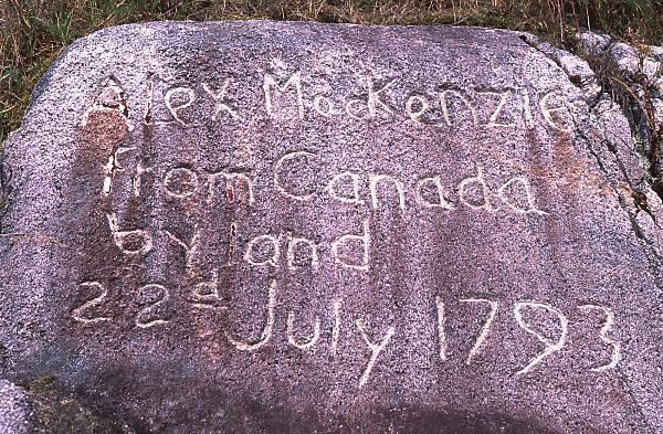
North Bentinck Arm is historically significant as the location where Northwest Fur Company explorer Alexander MacKenzie reached the waters of the Pacific Ocean overland from Lake Athabaska via the Peace and Fraser rivers, on 20 July, 1793. Needing to find an open area to make an astrological sighting, using the moons of the planet Jupiter, and determine longitude, he went by canoe with four Nuxalk natives the next day to Dean Channel, stopping at a site now part of Sir Alexander Mackenzie Provincial Park. A boulder on the shoreline there is marked with "Alexander MacKenzie, from Canada by land 22d July 1793". By only a few weeks MacKenzie missed meeting James Johnstone, one of Captain George Vancouver's men, who also visited North Bentinck Arm that year.
Name origin
North and South Bentinck Arms were named by George Vancouver, as "Bentinck Arms", in 1793, after the House of Portland; the Duke of Portland at the time was William Henry Cavendish Bentinck.
Indigenous territory
The inlet is the territory of the Nuxalk Nation, whose main community adjoins the town of Bella Coola, which is at the head of the inlet. The Nuxalk are also known as the Bella Coola people.