
Time zone UTC-4 Elevation 100 m Population 9,754 (2010) | Founded July 9, 1890 Postal Code 69355-000 Area 6,967 km² Local time Friday 5:47 AM | |
 | ||
Weather 24°C, Wind E at 14 km/h, 75% Humidity | ||
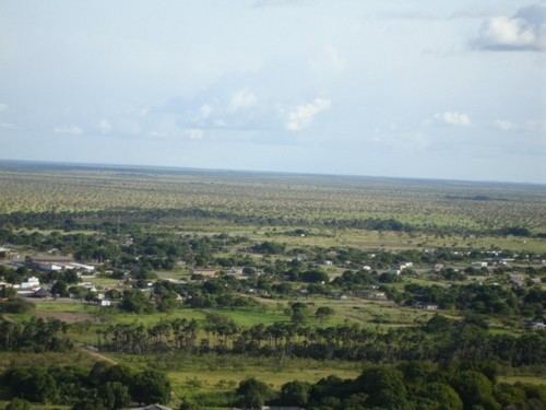
Normandia is a city located in the northeastern region of the Brazilian state of Roraima. Normandia covers 6,966.81 km2 (2,689.90 sq mi), and has a population of 9,754 with a population density of 1.28 inhabitants per square kilometer. The city consists almost entirely of indigenous areas; 98.6% of the land area of the city is part of the Raposa Serra do Sol indigenous reserve. The remaining area consists of the city seat located close to the Brazil-Guyana border.
Contents
- Map of Normandia State of Roraima Brazil
- Climate
- History
- Lake Caracaran
- Economy and infrastructure
- Transportation
- References
Map of Normandia - State of Roraima, Brazil
Climate
Normandia is located in an ecotone, a transition area between two biomes. The municipality sits between the great tropical Amazon rainforest region and the cerrado, an open Savanna-type grassland. The transition area is known locally as the lavrado. The lavrado of Roraima, and of Normandia, is relatively dry compared to the nearby Amazonian rainforest areas; it receives between 1,100 cm (430 in) and 1,400 cm (550 in) of precipitation per year.
History
Normandia takes its name from the city of Normandy in France, the birthplace of settler Henri Charrière, better known as "Papillon". Charrière was sentenced to serve time in a maximum security prison on Devil's Island in French Guiana. He and several inmates managed to escape from French Guiana to Brazil and settled in the area of present-day Normandia. While Charrière left the settlement after four or five years, other inmates became permanent residents. The Municipality of Normandia (Municipio de Normandia) was created by Federal Law No. 7,009 of July 1982, with land separated from the state capital of Boa Vista.
Lake Caracaranã
Lake Caracaranã, located in Normandia, is one of the tourist destinations of the state of Roriama. It has some tourist facilities and is located only 180 km (110 mi) from the state capitol of Boa Vista. Lake Caracaranã, with a perimeter of 5.8km, is surrounded by sandy beaches and native cashew trees. With the demarcation of the Raposa Serra do Sol indigenous reserve, access to the lake was closed. It reopened in 2013 and now tourists pay a nominal fee to visit the lake.
Economy and infrastructure
The main sources of income in Normandia are tourism (primarily to Lake Caracaranã), livestock, and mining. The city has one public hospital, Ruth Quitéria, with 22 beds, and a health clinic in the city seat, Health Centre Iracema Galvão. Several health posts serve the indigenous communities of Normandia. There is a special squad (located in Boa Vista) subject to the Jungle Infantry Brigade border that protects the city and controls its sole airport. Normandia has a system of water distribution, electricity (distributed by CER, through thermal), post office, bank branch and telephone network. There are 26 elementary schools and 2 high schools. Normandia has a single television channel, 7-TV Roraima, an affiliate of Rede Globo.
Transportation
Normandia is connected to the state capital of Boa Vista by a single highway, BR-401, a distance of 185 km (115 mi).