
OS grid reference TF122951 | Sovereign state United Kingdom Postcode district LN7 | |
 | ||
Normanby le Wold is a village and civil parish in the West Lindsey district of Lincolnshire, England. It is situated in the Lincolnshire Wolds, an Area of Outstanding Natural Beauty, and about 5 miles (8.0 km) south from the town of Caistor, and 17 miles (27 km) north-east from the city and county town of Lincoln. It is in the civil parish of Claxby by Normanby.
Contents
Map of Normanby le Wold, Market Rasen, UK
Close to Normanby le Wold village is a Trig pillar marking the highest point in Lincolnshire, 551 feet (167.9 m) above sea level. This area is known as Wolds Top.
History
The village had 37 households at the time of Domesday Book of 1086.
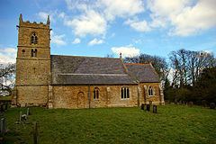
The Grade II* listed parish church is dedicated to Saint Peter and built of ironstone, dating from the early 13th century and the 14th century. It was restored in 1868 by James Fowler. Both the vestry and chancel are 19th-century, and the font is 14th-century on a 19th-century base. In the south aisle there is a 16th-century gravestone, seen through a large quatrefoil.
Community
St Peters church is part of the Walesby Group of Parishes which comprises Brookenby (St Michael and All Angels), Claxby by Normanby (St Mary), Kirmond le Mire (St Martin), North Willingham (St Thomas), Stainton le Vale (St Andrew), Tealby (All Saints), Walesby (St Mary) and Walesby Old Church (All Saints). The incumbent is The Revd John Carr assisted by The Revd Elaine Turner.