
District Gudbrandsdal Area rank 86 in Norway Area 1,141 km² Local time Wednesday 11:04 AM | County Oppland Demonym(s) Frøning Population 5,926 (2004) | |
 | ||
Weather 3°C, Wind NW at 5 km/h, 64% Humidity Points of interest Rondane National Park, Gudbrandsdal Krigsminnesamling, Frydalen landskapsvernområde | ||
Nord-Fron is a municipality in Oppland county, Norway. It is part of the traditional region of Gudbrandsdal. The administrative centre of the municipality is the village of Vinstra. The old municipality of Fron was divided into Nord-Fron and Sør-Fron in 1851. In 1966, they were merged back together again, but that only lasted until 1977 when they separated once again.
Contents
- Map of Nord Fron Municipality Norway
- Name
- Coat of arms
- History
- Geography
- Royal residence
- Eidefoss petroglyphs
- National parks
- Sister cities
- References
Map of Nord-Fron Municipality, Norway
Name
The Old Norse form of the name was Frón. The meaning of the name is unknown (maybe "earth" or "land"). Therefore, the meaning of Nord-Fron is "(the) northern (part of) Fron" (since the parish and municipality of Fron was divided in 1851.)
Coat-of-arms
The coat-of-arms is from modern times. They were granted on 18 July 1980. The arms show a gold-colored Dole Gudbrandsdal on a red background. The Fron area has a longstanding tradition in horse breeding and is one of the main centres of horse breeding in Norway. In the beginning of the century the Fron municipality used unofficial arms with a horse on it. After Fron was divided into Nord- and Sør-Fron, Nord-Fron choose the above arms.
(See also the coat-of-arms for Eid, Gloppen, Levanger, Lyngen, Skedsmo and Ski.)
History
The farm Nord-Hoge in Sødorp parish, Nord-Fron is the legendary home of Peer Gynt. Peer was made famous by both Peter Asbjørnsen's folk tales and Henrik Ibsen's play.
The body of Captain Sinclair is buried in Kvam.
The beautiful small church in Kvam, built in 1775, was burnt during the Occupation of Norway by Nazi Germany during World War II.
Geography
Nord-Fron is bordered to the north by Sel municipality, to the south and east by Sør-Fron, in the south by Gausdal and Øystre Slidre, and in the southwest by Vågå.
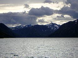
The district stretches from the mountains of Rondane and in the east to Jotunheimen in the west. A point of Nord-Fron "touches" Folldal municipality in Hedmark County.
There are two population centers in Nord-Fron: the villages of Vinstra and Kvam. Kvam is located at the northern end of the Peer Gynt Road, which passes through high roads with excellent views of the Jotunheimen, Dovrefjell, and Rondane mountain.
Lakes in the region include Feforvatnet.
Royal residence
The Royal Mountain Chalet, Prinsehytta is located in the valley of Sikkilsdalen. It is used as a Royal residence by the Norwegian Royal Family for hunting, Easter and winter holidays.
Eidefoss petroglyphs
The Rock carvings at Eidefoss are located on the east side of the river south of the white water.
National parks
Sister cities
The following cities are twinned with Nord-Fron: