
Country Canada Region Laurentides Settled 1883 Area 360.1 km² Local time Tuesday 10:56 PM | Province Quebec RCM Antoine-Labelle Constituted October 30, 1971 Population 2,019 (2011) | |
 | ||
Weather 1°C, Wind N at 3 km/h, 85% Humidity Points of interest Plage municipale, Parc Le Renouveau Rosaire-Sénécal, Baie des Beaubien | ||
Nominingue is a small village and municipality located 200 kilometres (120 mi) north of Montreal, Quebec, Canada, in the Laurentian Mountains. It was formerly called Lac-Nominingue, but changed name on September 16, 2000.
Contents
Map of Nominingue, QC, Canada
Nominingue is located along Route 117, between Mont-Laurier and Rivière-Rouge, and is near the International Airport of Rivière-Rouge/Mont-Tremblant.
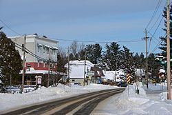
It is surrounded by dozens of lakes, including Petit and Grand Lac Nominingue, Lac des Grandes Baies, and Lac Sainte-Marie, as well as a forest. It is near Papineau-Labelle Wildlife Reserve and Rouge-Matawin Wildlife Reserve. The village was established in the late 1880s by pioneers sent by Curé Labelle to develop this mountainous and wild region. It was once the last station of the famous "P'tit train du Nord" (Little train of the North). Golf, biking, fishing and hunting are among the favourite outdoor activities. The former Canadian Pacific Railway station in Nominingue is now a small museum and rest stop for cyclists.
Demographics
Population trend:
Private dwellings occupied by usual residents: 936 (total dwellings: 1952)
Mother tongue: