
- elevation 1,160 m (3,806 ft) Length 160 km Mouth Lake Albert | - elevation 650 m (2,133 ft) Source Kibale | |
 | ||
- location Kigwabya, Western Region, Uganda | ||
River Nkusi is a river in Uganda, in East Africa.
Contents
Map of Nkusi River, Uganda
Location
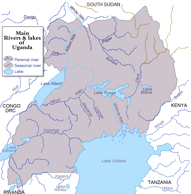
The Nkusi River is located in the western part of Uganda. It starts from the hills, west of the town of Kakumiro, in Kibaale District, Western Uganda. It flows in a northwesterly direction to enter a swamp near the village of Kitoma, also in Kibaale District. River Nkusi emerges from this swamp and flows westwards to empty into Lake Albert, at the International border between Uganda and the Democratic Republic of the Congo.
In the swamp near Kitoma, River Nkusi makes confluence with River Kafu. However, River Kafu flows out of the swamp in a northeasterly direction and finally empties into the Victoria Nile, near the town of Masindi Port, in Masindi District.
The source of River Nkusi is located in Kakumiro, with coordinates: Latitude:0.7955; Longitude:31.2190. River Nkusi enters Lake Albert at Kigwabya, in Kibaale District, with coordinates: Latitude:1.1195; Longitude:30.6670. The entire journey of River Nkusi is spent within the confines of Kibaale District. At its source, the altitude is approximately 1,160 metres (3,810 ft). At its point of entry into Lake Albert, the altitude is approximately 650 metres (2,130 ft).
The length of River Nkusi, is approximately 160 kilometres (99 mi) from source to end.