
District Ahmadnagar Founded by प Population 13,600 (2011) Local time Monday 5:43 PM | Time zone IST (UTC+5:30) Area code 02488 | |
 | ||
Weather 38°C, Wind NE at 10 km/h, 12% Humidity | ||
Nighoj potholes with western routes
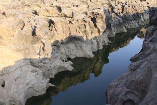
Nighoj (Marathi: निघोज)is a village in Ahmednagar District, Maharashtra, India. It is about 90 kilometres away from Pune and is famous for the naturally created potholes (tinajas) on the riverbed of the Kukadi River. Experts from all over the world come here every year to study the phenomenon of their formation.
Contents
- Nighoj potholes with western routes
- Map of Nighoj Maharashtra 414306
- Nighoj
- Schools
- Religion
- Temples
- Banks
- Places of interest
- References
Map of Nighoj, Maharashtra 414306
Geologists indicate that formerly there was greater rainfall in this area and that the Kukadi River flowed out from the highlands with such force that scouring of the bedrock took place and resulted in the formation of these potholes and the gorge.
Nighoj
Schools
Religion
The majority of the population in Nighoj is Hindu. But also there are few Muslims. There are several temples in the village. One of these temples, the Malaganga temple, is located on the bank of the gorge on the old river-bed itself and considered very auspicious. Every year there is a yatra of malaganga devi around 10 lac devotees come for pay their homage. There's a barav situated in the middle of nighoj this barav known for their hemadpanthi structure.
Temples
Banks
@ Co-operative Banks @ 1. Nighoj Nagari Sahakari Patsantha,Nighoj 2.Malganga sahkari Patsantha,Nighoj 3.Swami samarth Cooperative Bank,Nighoj
Places of interest
- Natural Pot Holes-Geographical Wonder