
Time zone CET (UTC+1) Website www.nieuwkoop.nl Local time Monday 12:13 PM | Elevation −5 m (−16 ft) Area code 0172, 0297 Area 91.18 km² | |
 | ||
Postcode 2420–2441, 2460–2461, 3651–3653 Weather 14°C, Wind SE at 13 km/h, 57% Humidity | ||
Nieuwkoop ( pronunciation ) is a town and municipality in the western Netherlands, in the province of South Holland. The municipality was enlarged on 1 January 2007, through the amalgamation of Liemeer and Ter Aar. The municipality now covers an area of 91.16 km2 (35.20 sq mi) of which 12.28 km2 (4.74 sq mi) is water. Its population was 27,122 in 2014.
Contents
Map of Nieuwkoop, Netherlands
On May 3rd, 2008, the Dutch newspaper het Algemeen Dagblad published an article which stated that Nieuwkoop is the safest municipality of the Netherlands.
The municipality of Nieuwkoop includes the following communities:
History
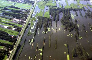
The oldest part of Nieuwkoop are the buildings along the Nieuwkoopse Plassen (Nieuwkoop's Ponds), many of which are completely surrounded by water and accessible over individual bridges to the main road. The Nieuwkoopse Plassen are shallow lakes that were dug for peat harvesting in the 16th century and are now designated as a natural monument. New neighborhoods north-west of the main road are built after World War II.