
Constructed November 1952 | Length 31.48 km | |
 | ||
Existed: November 1952 – present Counties Tioga County, New York, Tompkins County, New York | ||
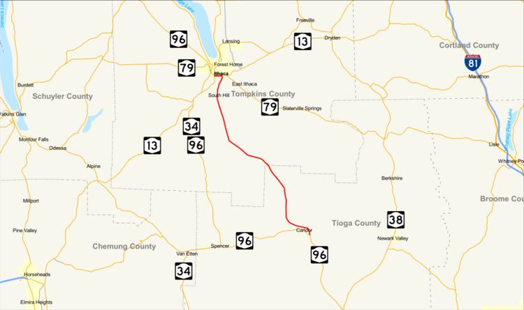
New York State Route 96B (NY 96B) is a north–south state highway in the Southern Tier of New York in the United States. It connects NY 96 in the village of Candor in Tioga County to NY 13, NY 34, and NY 96 in the city of Ithaca in Tompkins County. NY 96B approaches Ithaca from the south as Danby Road and then as South Aurora Street, before turning westward onto Clinton Street and proceeding to its northern terminus at a junction with NY 13, NY 34, and NY 96. The portion of NY 96B from the Ithaca city line to its northern terminus is maintained by the city.
Contents
Map of NY-96B, New York, USA
Route description
NY 96B begins at an intersection with NY 96 (Main Street), cosigned with NY 96 Truck, in the village of Candor. NY 96B proceeds northward along Owego Street as a two-lane residential street, passing west of a cemetery, and bending west as Owego Road. Changing names to Ithaca Road, the route intersects with County Route 17 (CR 17; Mill Street / Honeypot Road). Entering the town of Candor, NY 96B bends northward into the hamlet of Gridleyville, a rural area of Candor. After Gridleyille, NY 96B begins a winding alignment northward, passing to the southwest of Willseyville. After Willseyville, the route remains a two-lane northwest-bound highway, crossing the county line into Tompkins County and the town of Danby.
NY 96B remains a two-lane rural roadway after the county line, crossing northwest through Danby, passing by some creek-side residences. After intersecting with the northern terminus of CR 125 (South Danby Road), NY 96B bends towards the north, passing Danby Rural Cemetery. After a stretch of residences, the roadway passes into the hamlet of Danby, intersecting with CR 126 (Bald Hill Road). Continuing northward, CR 127 (West Miller Road) intersects with NY 96B, continuing northward through the town of Danby as Danby Road. After an intersection with CR 128 (Comfort Road), NY 96B enters the town of Ithaca. In Ithaca, NY 96B intersects with the western terminus of CR 179 (East King Road) south of the campus for Ithaca College.
Passing between Buttermilk Falls State Park and Ithaca College, NY 96B continues northward along Danby Road until entering the city of Ithaca. In the city, NY 96B changes monikers to South Aurora Street, crossing northeast through the South Hill neighborhood. The route becomes a two-lane residential street at the southern end of the city, passing Hillview Park before intersecting with Prospect Street, where NY 96B turns west onto Prospect, which becomes Clinton Street. Crossing over a waterway, NY 96B crosses through the Central Business District, as a two-lane residential street. A short distance later, NY 96B terminates at an intersection with NY 13, NY 34, and NY 96 (South Meadow Street / South Fulton Street).
History
The north–south highway connecting the village of Candor to the city of Ithaca was originally designated as part of Route 36, an unsigned legislative route assigned by the New York State Legislature in 1908. When the first set of posted routes in New York were assigned in 1924, this part of Route 36 was included in the new NY 15, a highway extending from Owego to Rochester. NY 15 was renumbered to NY 2 c. 1939 to eliminate numerical duplication with U.S. Route 15. NY 2 was subsequently renumbered to NY 96 in the early 1940s. In November 1952,, NY 96 was realigned between Candor and Ithaca to follow NY 223 to Spencer and NY 34 to Ithaca. The former routing of NY 96 between Candor and Ithaca was redesignated as NY 96B.