
Existed: 1930 – present Length 117.4 km | East end: NY 890 in Rotterdam Constructed 1930 | |
 | ||
Counties Oneida County, New York, Herkimer County, New York, Montgomery County, New York, Schenectady County, New York | ||
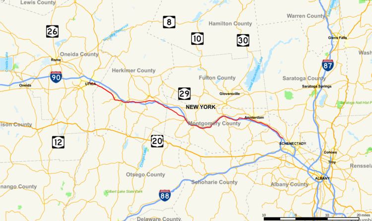
New York State Route 5S (NY 5S) is an east–west state highway located in the Mohawk Valley of New York in the United States. It extends for 72.92 miles (117.35 km) from an interchange with NY 5, NY 5A, NY 8, and NY 12 in Utica to a smaller interchange with NY 890 in Rotterdam. The route runs along the south side of the Mohawk River for its entire length and parallels NY 5, which runs along the north side of the Mohawk River (hence the "S" in the route number of NY 5S). In some locations, NY 5S has been upgraded into a super two or an expressway, mostly in Utica and western Herkimer County. The route is part of New York State Bicycle Route 5 west of its junction with NY 103 in Schenectady County.
Contents
Map of NY-5S, New York, USA
When NY 5S was assigned in 1930, the route stretched from Oneida in the west to Schenectady in the east. It was later truncated on both ends to eliminate overlaps with other state routes and to accommodate the construction of other roadways, most notably Interstate 890 (I-890) in western Schenectady.
Route description
NY 5S begins at an interchange with I-790 in downtown Utica, where Oriskany Street changes designations from NY 5A to NY 5S. At this interchange, I-790 is concurrent with NY 5, NY 8, and NY 12 along Utica's North–South Arterial. The freeway connects NY 5S to the New York State Thruway. From this interchange, NY 5S travels east across Utica as an urban arterial roadway with at grade intersections. After it crosses Broad Street, it continues east as a limited-access highway with grade-separated intersections to the Herkimer County line.
The highway meets Culver Avenue as it enters Herkimer County. Not far to the east is an interchange for Turner Street, a small connector road. Route 5S enters West Frankfort and has an exit for Dyke Road, which connects to the Thruway and NY 5. In West Frankfort, it parallels one of its many old alignments. Route 5S continues southward, encountering Higby Road and Cemetery Street in Frankfort. Just past the Herkimer County Fairgrounds, Route 5S crosses under NY 171. In East Frankfort, Route 5S intersects with its old routing and turns to the east. Route 5S enters Ilion, where it meets NY 51. Route 5S passes to the south of Herkimer and has junctions with local roads before intersecting NY 28 in Mohawk. While in Mohawk, Route 5S also intersects with NY 922B, an unsigned reference route.
Past Mohawk, Route 5S begins to parallel the Mohawk River and the Thruway as it continues eastward towards Rotterdam. Route 5S enters Little Falls and intersects with NY 167. Route 5S passes through farmlands and parallels the Thruway even farther, passing through the villages of Fort Plain and Canajoharie along the way. In the latter, NY 5S is village-maintained in the immediate vicinity of its junction with NY 10. This 0.19-mile (0.31 km) stretch is the only part of the route that is not maintained by the New York State Department of Transportation (NYSDOT).
Route 5S enters Fultonville and intersects with NY 30A. Route 5S begins to make different turns in direction and continues to parallel the Thruway. Route 5S enters Amsterdam and intersects with NY 30. Route 5S enters the Rotterdam area, paralleling Route 5 and the Mohawk River as it begins to head to the south. Route 5S comes to an end at an interchange with NY 890.
History
In 1908, the New York State Legislature created Route 6, an unsigned legislative route that began in Buffalo and proceeded eastward across New York to Albany. From Utica to Schenectady, Route 6 followed the banks of the Mohawk River through the Mohawk Valley. Initially, Route 6 used the modern NY 5S corridor from Utica to Mohawk and from Fultonville to Amsterdam. By 1920, the piece of what is now NY 5S from Mohawk to Little Falls became part of Route 26. On March 1, 1921, Route 26 was truncated to begin in Little Falls while Route 6 was realigned between Fultonville and Amsterdam to use NY 5 instead. When the first set of posted routes in New York were assigned in 1924, the portion of legislative Route 6 between Utica and Mohawk was designated as the northernmost portion of NY 28, a north–south route connecting Oneonta to Utica via Springfield and Richfield Springs.
In the 1930 renumbering of state highways in New York, NY 28 was rerouted north of Mohawk to follow its modern alignment toward Poland. Its former routing between Utica and Mohawk became part of NY 5S, an alternate route of NY 5 between Oneida and Schenectady. As its suffix implies, NY 5S was mostly a southerly alternate route of NY 5; however, it actually followed a more northerly routing than NY 5 west of Utica. It continued west to Oneida on what is now NY 5A, NY 69, NY 365, and NY 365A and east into Schenectady along Rice and River Roads. NY 5S was truncated eastward to Utica in the early 1940s, placing all of NY 5S south of NY 5 for the first time.
On its eastern end, NY 5S was gradually truncated to its current terminus in Rotterdam as portions of I-890 was built over the former routing of NY 5S between Rotterdam and Schenectady. The first cutback occurred in the early 1970s following the completion of I-890 between downtown Schenectady and exit 4. The freeway was completed between the New York State Thruway (I-90) and Schenectady in the mid-1970s, resulting in the truncation of NY 5S to I-890 exit 2. It was truncated to its current eastern terminus at I-890 (now NY 890) in the late 1980s after a reconfiguration of the interchange between the Thruway and I-890 resulted in the removal of River Road between I-890 and the current stub end of Rice Road.
From Utica to Mohawk, NY 5S was originally routed on "Old Route 5S" and Main Street. It was realigned in the early 1970s to follow a new freeway between Utica and Ilion that bypassed Frankfort to the west. A super two extension of the freeway east to Mohawk was completed sometime after 1982 (actually in 1992). On April 5, 1987, the bridge carrying the New York State Thruway over Schoharie Creek collapsed. At the time, the creek was higher and flowing faster than normal due to excessive rains in the area. The segment of NY 5S near Fort Hunter was reconfigured to carry westbound Thruway traffic while the bridge was rebuilt.