
Existed: early 1940s – present Counties: Washington | South end: NY 22 in Granville Length 17.08 km | |
 | ||
County | ||
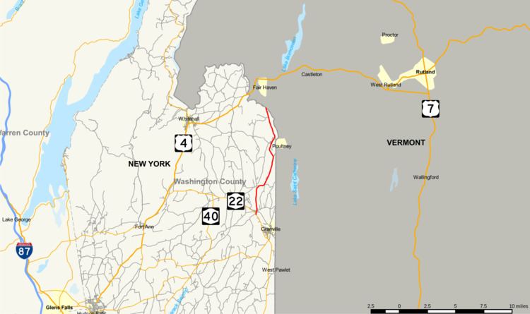
New York State Route 22A (NY 22A) is a short north–south state highway located within Washington County, New York, in the United States. The route extends for 10.6 miles (17.1 km) from an intersection with NY 22 in the town of Granville to the Vermont state line in the town of Hampton, where it becomes Vermont Route 22A (VT 22A). NY 22A was originally designated as New York State Route 286 in the 1930 renumbering of state highways in New York. It was renumbered to its current designation in the early 1940s.
Contents
Map of NY-22A, New York, USA
Route description
NY 22A begins at an intersection with NY 22 in the town of Granville. Crossing north through the hamlet of Middle Granville, NY 22A parallels the Mettawee River, reaching a junction with the eastern terminus of County Route 23 (CR 23). Passing a few homes through the center of Middle Granville, the route junctions with the terminus of CR 24. NY 22A continues north alongside the Mettawee, passing out of Middle Granville and into the rural areas of the town of Granville. At a fork, CR 21 proceeds north, while NY 22A turns northeast and crosses the Mettawee.
After a short eastern segment, NY 22A bends northeast again, entering the hamlet of Raceville, a small residential community. Rapidly approaching the Vermont state line, the route continues northeast through Granville, soon crossing into the town of Hampton. In Hampton, NY 22A turns northwest at a fork that marks the beginning of CR 20, which runs to the state border. Crossing northwest then northeast through Hampton, the route soon reaches a junction with CR 18, which once marked a junction with NY 273. At this junction, NY 22A enters the hamlet of Hampton, passing multiple homes before reaching a junction with CR 18A, which runs to the state line.
Just north of CR 18A, NY 22A turns northwest and leaves the hamlet of Hampton, crossing through the rural town of Hampton. Continuing a parallel with the Vermont state line, the route soon bends north and reaches the Poultney River, which marks the northern terminus of NY 22A. North of the Poultney River, the route continues north into Fair Haven, Vermont as VT 22A (Main Street).
History
What is now NY 22A was first designated as NY 286 as part of the 1930 renumbering of state highways in New York. It began at NY 22 in Middle Granville and went north to the Vermont state line, where it continued as VT 30A.The alignment of NY&nbp;22A was constructed in 1933 with bituminous macadam pavement. The road was 9 feet (2.7 m) wide in its lanes and contained 7 feet (2.1 m) shoulders. An alternate route of NY 286 along modern CR 20 and Greenfield Lane in Hampton and Granville, College, and York streets in Poultney, Vermont, was designated as NY 286A in New York and VT 286A in that state c. 1938. The New York half of the designation was short-lived as it was eliminated by the following year; however, VT 286A remained in place until the early 1940s. NY 286 was renumbered to NY 22A at some point between 1942 and 1944; Vermont followed suit by renumbering VT 30A to VT 22A by 1946.
The roadway of NY 22A was reconstructed in 1960 with concrete that made the road 10 feet (3.0 m) wide. The road was widened to 12 feet (3.7 m) wide in 1970 and repaved once again in 1988.
Major intersections
The entire route is in Washington County.