
Existed: 1930 – present Counties: Columbia Constructed 1930 | Length 10.91 km | |
 | ||
East end: | ||
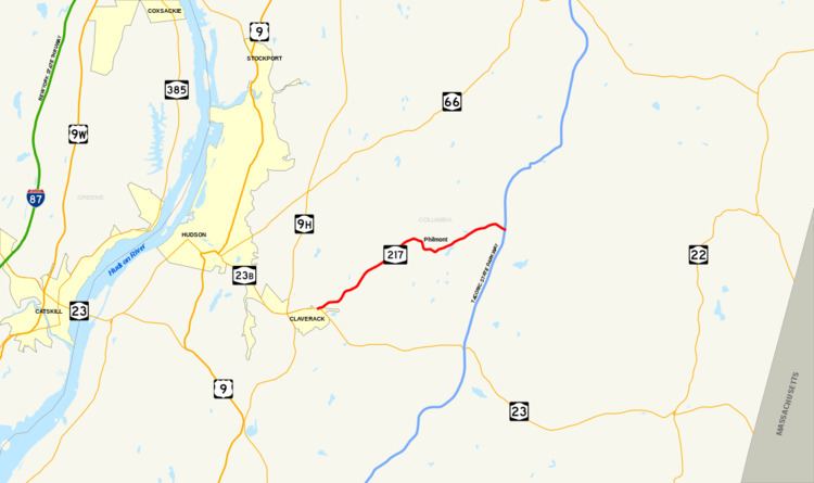
New York State Route 217 (NY 217) is a 6.78-mile (10.91 km) long state highway in Columbia County, New York, in the United States. It connects NY 23 in Claverack to the Taconic State Parkway in Ghent by way of the village of Philmont. The majority of NY 217 is a rural highway, excluding portions near the NY 23 junction and in Philmont.
Contents
Map of NY-217, Hudson, NY 12534, USA
NY 217 originally extended from Mellenville to NY 22 in the town of Hillsdale when it was assigned as part of the 1930 renumbering of state highways in New York. It was extended west to its present terminus in Claverack in the early 1930s. NY 217 was truncated westward to Harlemville in the mid-1930s, then to the Taconic Parkway in 1980. The former routing of NY 217 is now maintained by Columbia County as County Route 21 (CR 21) and County Route 21C.
Route description
NY 217 begins at an intersection with NY 23 east of the hamlet of Claverack in the town of the same name in central Columbia County. The route heads northeastward from the intersection, passing by the historic Stephen Storm House at the outskirts of Claverack hamlet and into a rural portion of the town. At an intersection with Roxbury Road, NY 217 passes the Columbia Golf and Country Club to the west and begins to parallel Claverack Creek. NY 217 intersects with CR 18 (Fish and Game Road), then enters the populous hamlet of Mellenville.
In the center of Mellenville, NY 217 intersects with CR 9 (Mellenville Road), with NY 217 serving as CR 9's southern terminus. NY 217 then heads southeast, crossing Claverack Creek and passing Mellenville Union Cemetery to the north as well as the adjacent Claverack Town Park. The route turns eastward and meets the northern terminus of Roxbury Road as it enters the village of Philmont. Within Philmont, NY 217 follows Main Street through the center of the densely populated village. At an intersection with Maple Street, the highway comes within view of Summit Lake, a small water body in the center of Philmont. Past the lake, NY 217 turns northeast once more and intersects with CR 11 (Martindale Road) as it leaves the village.
After Philmont, NY 217 progresses its way northeastward, with the highway winding its way through a mixture of dense woods and open fields. Shortly after crossing into the town of Ghent, the route turns eastward and the woods around the highway begin to cease. Here, NY 217 ends at the Taconic State Parkway by way of a parclo interchange.
History
The north–south roadway connecting the hamlets of Claverack and Mellenville (both located within the town of Claverack) was originally designated as the southernmost part of NY 66 in the mid-1920s. A connector between NY 66 in Mellenville and NY 22 in North Hillsdale via Philmont was designated as NY 217 as part of the 1930 renumbering of state highways in New York. NY 66 was rerouted south of the hamlet of Ghent c. 1933 to follow its modern alignment to the city of Hudson. NY 217 was then extended southwestward along NY 66's former alignment to NY 23 east of Claverack.
NY 217 was truncated on its eastern end to Harlemville c. 1935. On April 1, 1980, NY 217 was truncated again, this time to its interchange with the Taconic State Parkway, as a result of a highway maintenance swap between the state of New York and Columbia County. The former routing of NY 217 from Harlemville to North Hillsdale is now CR 21 while the portion from the Taconic Parkway to Harlemville is designated as CR 21C.
Major intersections
The entire route is in Columbia County.