
Existed: 1953 – present Length 6.36 km | Constructed 1953 | |
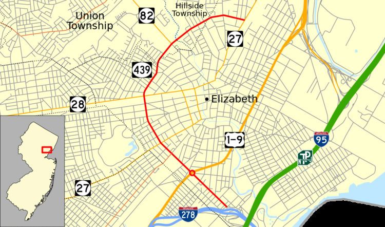 | ||
Route 439 is a short state highway in the communities of Linden and Elizabeth in Union County, New Jersey. The highway is known as the Bayway, North Avenue and Elmora Avenue from the Goethals Bridge and Interstate 278 in Linden and does a loop around Elizabeth, with the designation terminating at an intersection with New Jersey Route 27 in Elizabeth. The highway originated as part of Route 28 south of the current intersection with New Jersey Route 28 and Route S24 (which made up several routes) north of that intersection to New Jersey Route 82. The current designation of NJ 439 was assigned in the 1953 renumbering.
Contents
Map of NJ-439, Elizabeth, NJ, USA
Route description
New Jersey Route 439 begins at an intersection with Union County Route 616 and Interstate 278 near the Goethals Bridge in Elizabeth. The highway progresses westward, passing to the south of the Number 22 Elementary School. The surroundings of the highway are densely populated, with buildings surrounding the highway the entire time. Turning to the northeast, Route 439 intersects with the southern terminus of County Route 623 (South Broad Street) and enters the small community of Bayway, for which the highway is named. There, the route intersects with U.S. Routes 1 & 9 at the Bayway Circle, where it changes monikers to South Elmora Avenue and continues deeper into Elizabeth.
After the Bayway Circle, Route 439 continues to the northeast and into Elizabeth, where it intersects with County Route 656 (Lidgerwood Avenue) and crosses the New Jersey Transit railroad line nearby. The highway then intersects with the northern terminus of County Route 514, which heads southward. The development becomes more residential for a short time along Route 439, until the first intersection with New Jersey Route 27 (Rahway Avenue), where the commercial development experienced earlier returns. After NJ 27, the route's loop begins to turn even further northward, where it enters Elmora. The highway passes to the southwest of Carteret Park and soon leaves Elmora.
North of Elmora, Route 439 intersects with County Route 610 (West Grand Street) and New Jersey Route 28 (Westfield Avenue), both of which parallel each other for several miles. After the intersection with NJ 28, the highway begins the turn to the east once again. At an intersection with Chilton Street, the highway changes monikers to North Avenue, which it retains for the remaining length. During the curve, Route 439 enters Union and intersects with the southern terminus of New Jersey Route 82, where Kean University and Phil Rizzuto Park both surround the highway. After NJ 82, the highway enters Hillside and begins the eastward progression, passing to the south of Elizabeth River Park. After the curve completes, Route 439 enters Elizabeth again and intersects with County Route 623 once again and continues a short distance, where it terminates at the second intersection with NJ 27. North Avenue continues eastward to an interchange with New Jersey Route 81.
History
NJ 439 originates as an alignment of New Jersey State Highway Route 28, assigned in the 1927 New Jersey state highway renumbering from NJ 28 to the intersection with U.S. Routes 1 and 9. The highway was set to serve a new Staten Island crossing, which finally opened on June 29, 1928. The highway north of NJ 28 and progressed north to the current day intersection with NJ 82 was New Jersey State Highway Route S-24, which a spur of New Jersey Route 24 from Phillipsburg to Elizabeth. The designations remained intact for over two decades, but across the Arthur Kill in Staten Island, New York State Route 439 was assigned onto the Goethals Bridge, and when the 1953 New Jersey state highway renumbering occurred on January 1, 1953, the highway was redesignated as NJ 439 to match up at the state line. The NJ alignment has remained intact since, but the New York alignment was decommissioned in 1968.
Major intersections
The entire route is in Union County.