
Country United States Website [1] Area 5.4 km² Population 5,417 (2013) Local time Saturday 7:47 AM | Time zone EST (UTC-5) Elevation 151 m Zip code 17557 Mayor Wilbur G. Horning | |
 | ||
Area code(s) 717 Exchanges: 351,354,355 Weather 10°C, Wind S at 5 km/h, 77% Humidity | ||
New Holland (Pennsylvania Dutch: Seischwamm) is a borough in Lancaster County, Pennsylvania, USA. As of the 2010 United States Census, the population was 5,378, up from 5,092 in the 2000 United States Census.
Contents
Map of New Holland, PA 17557, USA
History
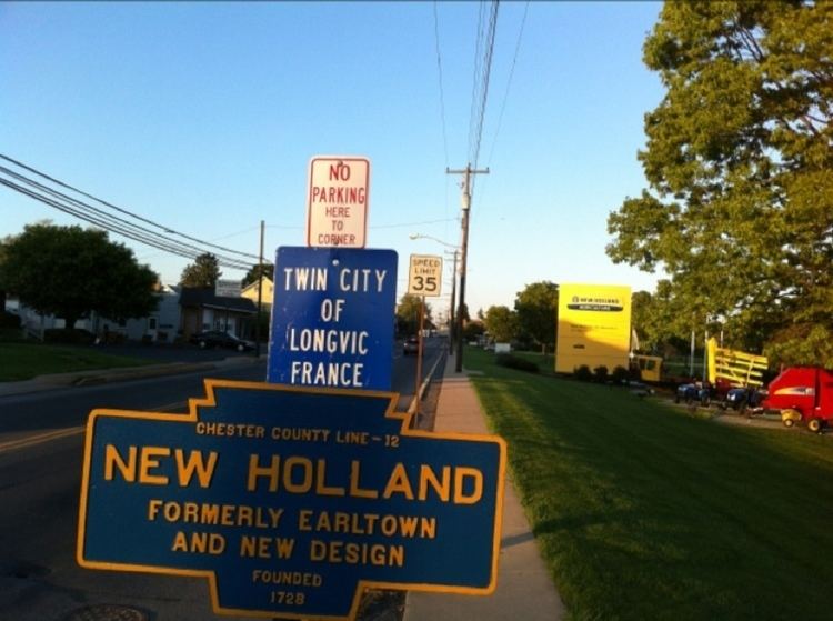
New Holland was settled in 1728 by John Michael and John Phillip Ranc (Ranck). Before it became known as New Holland, it had been called Hog Swamp, Earltown and New Design. New Holland, Pennsylvania is the twin city of Longvic, France.
The New Holland Machine Company and John Casper Stoever Log House are listed on the National Register of Historic Places.
Geography
New Holland is located at 40°6′8″N 76°5′16″W (40.102095, -76.087646). According to the United States Census Bureau, the borough has a total area of 2.1 square miles (5.4 km2), all of it land.
Rail
New Holland is a terminus of the New Holland Secondary Rail Line, which splits off of the Amtrak Keystone Line just east of Lancaster Station in Lancaster, Pennsylvania. The line is owned by Norfolk Southern Railway, and is operated often to supply a number of businesses along the way, notably, RR Donnelley and Sons Printing, in Lancaster, Pennsylvania, as well as one of the Dart Container factories, and L&S Sweeteners, both in Leola, Pennsylvania.
Demographics
As of the census of 2000, there were 5,092 people, 2,084 households, and 1,448 families residing in the borough. The population density was 2,444.2 people per square mile (945.2/km²). There were 2,159 housing units at an average density of 1,036.3 per square mile (400.8/km²). The racial makeup of the borough was 90.34% White, 1.02% African American, 0.08% Native American, .025% Asian, 0.02% Pacific Islander, 2.57% from other races, and 1.67% from two or more races. Hispanic or Latino of any race were 6.42% of the population.
In the borough the population was spread out, with 22.4% under the age of 18, 8.1% from 18 to 24, 28.6% from 25 to 44, 24.9% from 45 to 64, and 16.1% who were 65 years of age or older. The median age was 40 years. For every 100 females there were 95.3 males. For every 100 females age 18 and over, there were 94.1 males.
The median income for a household in the borough was $44,446, and the median income for a family was $50,758. Males had a median income of $37,002 versus $25,766 for females. The per capita income for the borough was $20,187. About 3.4% of families and 5.2% of the population were below the poverty line, including 7.5% of those under age 18 and 1.5% of those age 65 or over.
Education
The Eastern Lancaster County School District has its district headquarters in New Holland, Pennsylvania. This site also houses both Garden Spot High School and Garden Spot Middle School. Elementary schools within the district include: New Holland, Blue Ball and Brecknock.
This area is served by the Eastern Lancaster County Library http://www.elancolibrary.org (ELANCO Library), formerly known as New Holland Library. The ELANCO Library is located on Chestnut St. in New Holland and is a member of the Library System of Lancaster County.
Culture
The New Holland Farmer's Fair is an annual festival held in New Holland.