
Population 82 (2001 Census) Sovereign state United Kingdom Postcode district DG2 Local time Saturday 4:31 AM | Dialling code 01387 | |
 | ||
Weather -1°C, Wind N at 3 km/h, 96% Humidity Lieutenancy areas Dumfries and Galloway, Dumfriesshire | ||
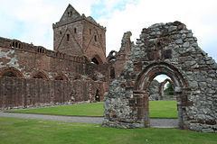
Sweetheart abbey new abbey dumfries scotland
New Abbey is a village in Dumfries and Galloway, south-west Scotland. It is around 6 miles (10 km) south of Dumfries. The summit of the prominent hill Criffel is 2.5 miles (4.0 km) to the south.
Contents
- Sweetheart abbey new abbey dumfries scotland
- Map of New Abbey Dumfries UK
- New abbey issue title on the move 1940
- Notable people
- List of listed buildings
- References
Map of New Abbey, Dumfries, UK
The village has a wealth of history including the ruined Cistercian abbey Sweetheart Abbey, founded by Lady Devorgilla in 1273 to commemorate the death of her husband John Balliol. The monks named the abbey dulce cor ("sweet heart"). The village has a watermill, the New Abbey Corn Mill. Loch Kindar has a crannog and the village has the remains of Kirk Kindar (this was the parish church until just after 1633 when it was transferred to the refectory of the suppressed Sweetheart Abbey) on an island located just outside the village.
The village has a saw mill, a hotel, a village shop, a coffee shop, a primary school, a doctor's surgery, a village hall, a bowling green, a football pitch - Maryfield Park (home to Abbey Vale FC), a Church of Scotland church, and a Roman Catholic church.
Two burns flow through the village: the New Abbey Pow which runs into the River Nith Estuary and the Sheep Burn.
New abbey issue title on the move 1940
Notable people
List of listed buildings
List of listed buildings in New Abbey, Dumfries and Galloway