
Isolation 118.39 km (73.56 mi) Easiest route road, hiking trail Last eruption 1350 BC | Elevation 4,680 m Prominence 2,210 m | |
 | ||
Mountain range Trans-Mexican Volcanic Belt Similar Iztaccihuatl, Popocatépetl, Pico de Orizaba, Malinche, Ajusco | ||
La investigacion extrema del ovni esf rico en el nevado de toluca 4 de enero del 2014 hd
Nevado de Toluca (: ne'βado de to'luka ) is a large stratovolcano in central Mexico, located about 80 kilometres (50 mi) west of Mexico City near the city of Toluca. It is generally cited as the fourth highest of Mexico's peaks, after Pico de Orizaba, Popocatépetl and Iztaccíhuatl, although by some measurements, Sierra Negra is slightly higher.
Contents
- La investigacion extrema del ovni esf rico en el nevado de toluca 4 de enero del 2014 hd
- Map of Nevado de Toluca State of Mexico Mexico
- EtymologyEdit
- DescriptionEdit
- ClimateEdit
- Archeological sitesEdit
- References
Map of Nevado de Toluca, State of Mexico, Mexico
EtymologyEdit
It is often called by the Nahuatl name Xinantecatl which is usually translate as The Naked Lord, Señor Desnudo in Spanish, although other etymologies have been suggested such as "Lord of the Corn Stalks", Tzinacantecatl or Zinacantepec (Mountain of the Bats). Recently other evidence regarding the etymologies of this mountain have surfaced and after many archeology discoveries in and around the area. It has been concluded that its correct etymology is Chicnauhtecatl meaning "nine lakes" as the top of the cone has various deep lakes.
DescriptionEdit
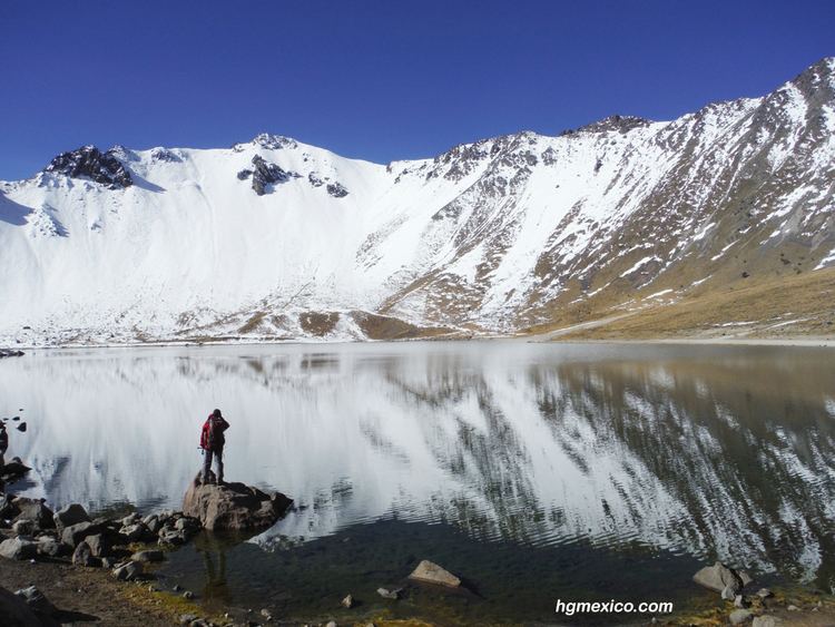
The volcano has a 1.5-kilometre (0.93 mi) wide summit caldera which is open to the east. The highest summit, 4,680-metre (15,354 ft) Pico del Fraile (Friar's Peak), is on the southwest side of the crater and the second highest, 4,640-metre (15,223 ft) Pico del Aguila (Eagle's Peak), is on the northwest. There are two crater lakes on the floor of the basin at about 4,200 m (13,800 ft), the larger Lago del Sol (Sun Lake) and the smaller, but deeper, Lago de la Luna (Moon Lake). A road formerly ran into the caldera to the lakes, making this perhaps the most accessible major Mexican peak. The road is now gated 2 km before the lakes.
The last major eruption of Nevado de Toluca occurred about 10,500 years ago (10.5 ka BP), as the volcano erupted a total estimated volume of 14 km3 for a VEI strength of 6 (comparable to the 1991 eruption of Mount Pinatubo). The eruption emplaced 1.5 m (5 ft) of pebble-sized pumice in the City of Toluca region and ~50 cm (2 ft) of medium to fine sand in the Mexico City region. Distal lahar deposits derived from the Upper Toluca Pumice event incorporated mammoth bones and other mammals in the basin of Mexico. A future event of this magnitude would disrupt the lives of 30 million people now living in these cities and their surroundings.
From the southeast, Nevado de Toluca looks flat-topped, like shoulders without a head. A Nahuatl legend (recounted as part of the legend of Popocatépetl and Iztaccíhuatl) provides a mythical explanation.
The volcano and the area around it is now a national park.
ClimateEdit
Near the summit, Nevado de Toluca has a cold alpine climate (Köppen climate classification ET) with cold temperatures year round. There is little variation in the temperatures and frost and snow can occur in any month. The dry season covers from November to March and precipitation is low, averaging 12.4 millimetres (0.49 in) in March, the driest month. Temperatures during this time are cold, averaging 2.3 °C (36.1 °F) in January. The wet season spans from May to October and precipitation is very high, averaging 243.5 millimetres (10 in) in July. The summit is often foggy, averaging 110 days with fog, most of it during the rainy season. The wettest record month was July 2008 when 513.5 millimetres (20 in) of precipitation fell and the wettest recorded day was July 16, 1999 when 90.5 millimetres (4 in) of precipitation fell. The highest temperature ever recorded was 23 °C (73.4 °F) on August 16, 1993 and the lowest temperature recorded was −10 °C (14.0 °F) on February 2, 2004.
Archeological sitesEdit
There are 18 registered archeological sites in the park, as this was a ritual center during pre-Hispanic periods. Bernardino de Sahagún wrote about the lakes as a place where the indigenous held ceremonies and sacrifices. The lakes themselves are considered to be two sites, as a large number of offerings, especially copal, were deposited in the lakes. These deposits can be found all over the lakebed as the burning copal was set adrift on the lakes’ waters until it sank. Other objects have been found such as ceramics and sculpted stones. Divers used to sack many of the pieces found here but now authorities carefully monitor those who dive.
Most of the other sites are found on the crater's walls and peaks. One of the sites is called Xicotepec which is at the top of the Cerro de Ombligo (Spanish for belly button). Principally green obsidian blades and multicolored ceramic has been found here. On the north side of the crater is Pico Sahagun, with ceramic pieces, Picos Heilprin North and South in which various types of objects have been found, and El Mirador, which is thought to be related the marking of the zenith of the sun. A stele found here seems to indicate this. The site at the highest altitude is Pico Noreste at 4,130 meters above sea level. It is a small platform with drainage on which has been found highly deteriorated ceramic pieces. On the west side is the Cerro Prieto Cave, which is really a rock shelter which is more than 60 meters high. Not only does it contain evidence of pre-Hispanic visits but also has been a shrine to the Archangel Michael since the colonial period.
There have been intermittent archeological excavations here with the most recent occurring in 2010 sponsored by INAH which found artifacts dating from the Epi-Classic (650-900 AD) and Post-Classic (900-1200 AD) periods and showed that the crater was a meeting place for astronomer priests to predict the growing season.