Country Russia Rural okrugs 1 Area 98,890 km² | Settlements 6 Cities/towns 1 Founded 1975 | |
 | ||
Neryungrinsky District (Russian: Нерюнгри́нский улу́с; Yakut: Нүөрүҥгүрү улууһа, Nüörüñgürü uluuha, [nyøɾyŋgyɾy uluːha]) is an administrative and municipal district (raion, or ulus), one of the thirty-four in the Sakha Republic, Russia. It is the southernmost district of Sakha and borders Aldansky District in the north, Olyokminsky District in the west and northwest, Amur Oblast and a small area of Zabaykalsky Krai in the south, and Khabarovsk Krai in the east. The area of the district is 98,900 square kilometers (38,200 sq mi). Its administrative center is the town of Neryungri. Population (excluding the administrative center): 21,019 (2010 Census).
Contents
Geography
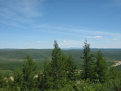
The landscape of the district is mostly mountainous. The main river in the district is the Aldan with its tributaries the Timpton and the Chulman. The largest lake is Lake Bolshoye Toko.
Climate
Average January temperature ranges from −30 °C (−22 °F) to −34 °C (−29 °F) and average July temperature ranges from +12 °C (54 °F) to +14 °C (57 °F). Annual precipitation is 400–500 millimeters (16–20 in).
History
The district was established on November 6, 1975.
Demographics
As of the 1989 Census, the ethnic composition was as follows:
Economy
There are deposits of gold, coal, iron ore, molybdenum, and construction materials in the district.
Administrative divisions
The district includes seven municipal divisions, covering a total of nine inhabited locations.
Divisional source:
Population source:
*Administrative centers are shown in bold
