
Country United States FIPS code 27-45196 Elevation 363 m Zip code 55053 Local time Friday 8:18 AM | Time zone Central (CST) (UTC-6) GNIS feature ID 0648482 Area 3.68 km² Population 298 (2013) Area code 507 | |
 | ||
Weather 3°C, Wind N at 10 km/h, 96% Humidity | ||
Nerstrand is a city in Rice County, Minnesota, United States. The population was 295 at the 2010 census.
Contents
- Map of Nerstrand MN 55053 USA
- History
- LawGovernment
- Geography
- Economy
- 2010 census
- 2000 census
- Notable natives
- References
Map of Nerstrand, MN 55053, USA
Minnesota State Highway 246 serves as a main route in the community. Minnesota State Highways 56 and 60 are nearby.
History
In 1856, Norwegian immigrant Osmund Osmundson moved to Wheeling Township in Rice County. He homesteaded the present site of Nerstrand, building a house and farm, and began to envision a town on the site. In 1877, he built a store on what became the right-of-way for railroad tracks on what is now Main Street. In 1885, the Minnesota and North Western Railroad (later the Chicago Great Western Railway) was constructed, extending from Lyle, Minnesota to St. Paul, and Osmundson platted the town on the line, naming it after his hometown of Nedstrand in Tysvær, Norway.
The town was the center of a significant Norwegian immigrant community, which included people in the surrounding township and county. Some, like Tosten Bonde, who lived just outside the city limits, and Osmundson became state legislators. Thorstein Veblen, who similarly grew up just outside the town, became a noted sociologist and economist.
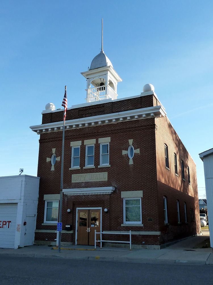
The town incorporated in 1897 and its first city hall, built in the same year. It proved too small within a few years, and a new city hall was built in 1907. The Nerstrand City Hall building was placed on the National Register of Historic Places on April 6, 1982 alongside the Osmund Osmundson House and Tosten Bonde's farmhouse. The Thorstein Veblen Farmstead became a National Historic Landmark. The railroad tracks have since been removed.
Law/Government
The office of mayor is vacant as of September 2016.
Geography
According to the United States Census Bureau, the city has a total area of 1.42 square miles (3.68 km2), all of it land. The town features an elementary school with grades K-5, which is operated as a charter school under state law. There is also a highly rated volunteer fire department.
Nerstrand-Big Woods State Park is located nearby. The Valley Grove Church Building, located nearby, is considered an important historical site, though there are several active churches around the area that are better preserved:
The town was notorious for the nearby Nerstrand Hill, bane of the locomotive engineer, with the steepest grade on the line from St. Paul to Manley Junction, Iowa.
Economy
Throughout its history, the town has acted as a source of services to area farmers. An implement dealer and a full-service grain elevator are still present today carrying on this role. These two businesses together provide over half the employment in Nerstrand.
The business district declined with the advent of the automobile, with most area residents choosing to shop in Northfield which has always been more prominent because of the two colleges located there, or Faribault which is the county seat.
As businesses left, Nerstrand became more of a bedroom community for people working in Northfield, Faribault, or Kenyon. A few nonretail businesses, including a cabinet shop and two specialty construction firms, have come to the community, utilizing what would otherwise be vacant storefront space.
2010 census
As of the census of 2010, there were 295 people, 108 households, and 91 families residing in the city. The population density was 207.7 inhabitants per square mile (80.2/km2). There were 120 housing units at an average density of 84.5 per square mile (32.6/km2). The racial makeup of the city was 96.9% White, 0.3% Native American, 0.7% Asian, 1.7% from other races, and 0.3% from two or more races. Hispanic or Latino of any race were 3.1% of the population.
There were 108 households of which 40.7% had children under the age of 18 living with them, 73.1% were married couples living together, 6.5% had a female householder with no husband present, 4.6% had a male householder with no wife present, and 15.7% were non-families. 12.0% of all households were made up of individuals and 3.7% had someone living alone who was 65 years of age or older. The average household size was 2.73 and the average family size was 2.96.
The median age in the city was 37.1 years. 28.1% of residents were under the age of 18; 4.5% were between the ages of 18 and 24; 29.5% were from 25 to 44; 22.8% were from 45 to 64; and 15.3% were 65 years of age or older. The gender makeup of the city was 47.8% male and 52.2% female.
2000 census
As of the census of 2000, there were 233 people, 80 households, and 65 families residing in the city. The population density was 164.3 people per square mile (63.4/km²). There were 82 housing units at an average density of 57.8 per square mile (22.3/km²).
There were 80 households out of which 45.0% had children under the age of 18 living with them, 72.5% were married couples living together, 7.5% had a female householder with no husband present, and 18.8% were non-families. 16.3% of all households were made up of individuals and 10.0% had someone living alone who was 65 years of age or older. The average household size was 2.91 and the average family size was 3.26.
In the city, the population was spread out with 33.9% under the age of 18, 4.3% from 18 to 24, 33.9% from 25 to 44, 15.0% from 45 to 64, and 12.9% who were 65 years of age or older. The median age was 33 years. For every 100 females there were 91.0 males. For every 100 females age 18 and over, there were 90.1 males.
The median income for a household in the city was $41,500, and the median income for a family was $50,156. Males had a median income of $32,500 versus $23,333 for females. The per capita income for the city was $15,362. None of the families and 0.4% of the population were living below the poverty line.
Notable natives
Thorstein Veblen (1857–1929), usually characterized as an economist or sociologist, and best known for writing the book The Theory of the Leisure Class (ISBN 0-14-018795-2), lived about a mile northeast of town. His house and farm, The Thorstein Veblen Farmstead, contained several innovations, including what is believed to be the first bucket elevator to be installed on a farm in Rice County. The Thorstein Veblen Farmstead was renovated in 1994 as a historic site and is occasionally open to the public. As of September 2016, it is a flower farm.