
Postal code 02128 | ||
 | ||
Location | ||
Neptune Road is located in the East Boston neighborhood of Boston, Massachusetts. The road is fragmented, bisected by the Massachusetts Bay Transportation Authority's Blue Line which surfaces from the subway southwest of the road. Much of the portion southeast of the train tracks is encompassed within Logan International Airport.
Contents
Map of Neptune Rd, Boston, MA 02128, USA
History
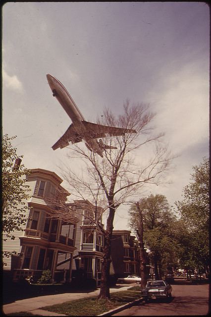
Neptune Road once was a residential street that also served as the entrance to Frederick Law Olmsted's Wood Island Park, a 47-acre waterfront park designed by Olmsted in the 19th Century. An elegant tree-lined road with center islands, The Boston Globe referred to the street as a “miniature Commonwealth Avenue”.
The expansion of Logan Airport in the late 1960s and early 1970s displaced families along Neptune Road, which is now used for warehouses and rental car property. As the airport expanded, planes flew in low over the residential blocks and conflicts with airport officials escalated. Wood Island Park was leveled early one morning in 1967. On April 23, 1969, 35 workmen with 35 chain saws toppled 35 elms along the road. The Massachusetts Port Authority, under the reign of then-director and later Governor of Massachusetts Edward J. King, seized by eminent domain some 720 feet of the street, and evicted families with the help of US Marshalls.
The airport has since implemented four "airport edge buffers," which include parks and greenery. Some of Boston’s last surviving elm trees are still located on Neptune Road, resisting the Dutch elm disease that have felled most of the Boston-area elms in the 20th Century.