
- location south of Mittagong - location Nattai | - elevation 452 m (1,483 ft) - elevation 116 m (381 ft) | |
 | ||
- left Wanganderry Creek, Allum River Mouths | ||
The Nattai River, a perennial river that is part of the Hawkesbury-Nepean catchment, is located in the Southern Highlands region of New South Wales, Australia.
Contents
Map of Nattai River, New South Wales, Australia
Course and features
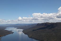
The Nattai River rises on the Mittagong Range within the Great Dividing Range, south of Mittagong, and flows generally north northwest and then north northeast, joined by nine tributaries including the Little River, before reaching its confluence with the Wollondilly River within Lake Burragorang southwest of the locality of Nattai. The river descends 336 metres (1,102 ft) over its 51-kilometre (32 mi) course.
The river flows through the Nattai National Park and is a source of water for the Sydney region.
References
Nattai River Wikipedia(Text) CC BY-SA