
Coastline 192.4 km (119.55 mi) Population 0 Area 1,466 km² | Highest elevation 1,067 m (3,501 ft) Elevation 1,067 m | |
 | ||
Zone Northeast Greenland National Park | ||
Nares Land or Naresland is an island in far northern Greenland. The island is named after Polar explorer Sir George Nares.
Contents
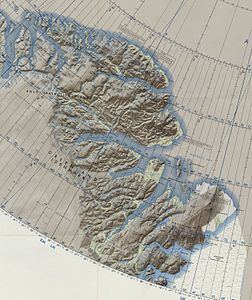
Map of Nares Land, Greenland
Geography
The island lies between the Victoria Fjord and the Nordenskjöld Fjord separated from the mainland by a narrow sound. Stephenson Island and John Murray Island lie off its northern end. Nares Land is fairly large, with an area of 1,466 square kilometres (566 square miles) and a shoreline of 192.4 kilometres (119.6 miles). It is 75 kilometres (47 miles) long and up to 30 kilometres (19 miles) wide in its widest place. It has an average elevation of 161 metres (528 feet) and its highest point is 1,067 metres (3,501 feet).
The area where the island lies has a severe Polar climate and was formerly part of Avannaa, originally Nordgrønland ("North Greenland"), a former county of Greenland until 31 December 2008. The sea around the island is frozen practically the whole year round.