
Postcode(s) 5550 Nantawarra Mount Templeton | State electorate(s) FromeGoyder Postal code 5550 | |
 | ||
Location 120 km (75 mi) north of Adelaide city centre25 km (16 mi) north of Port Wakefield12 km (7 mi) south of Snowtown Federal divisions Division of Grey, Division of Wakefield | ||
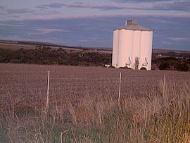
Nantawarra is a locality in South Australia located about 120 kilometres (75 mi) north of the Adelaide city centre and within the local government area known as the Wakefield Regional Council. The locality occupies land on both sides of Highway 1 between Port Wakefield in the south and Snowtown in the north. Nantawarra is recognisable from a distance by the presence of grain silos immediately just east of the Adelaide-Port Augusta railway line. The name Nantawarra may derive from the word nantuwara (meaning a northern yerta, or family group) in Kaurna, the language of the indigenous people of this part of South Australia.
Map of Nantawarra SA 5550, Australia
References
Nantawarra, South Australia Wikipedia(Text) CC BY-SA