
Country United States County Essex Incorporated 1853 Area 40.1 km² Population 3,410 (2010) | State Massachusetts Settled 1630 Elevation 50 ft (15 m) Zip code 01908 Local time Sunday 10:17 PM | |
 | ||
Weather 2°C, Wind N at 18 km/h, 63% Humidity | ||
Nahant /nəˈhɑːnt/ is a town in Essex County, Massachusetts, United States. The population was 3,410 at the 2010 census. With just 1.0 square mile (2.7 km2) of land area, it is the smallest municipality by area in the state. It is primarily a residential community.
Contents
- Map of Nahant MA USA
- History
- Development
- Geography and transportation
- Demographics
- Points of interest
- Annual events
- In popular culture
- References
Map of Nahant, MA, USA
History
Native Americans called the area Nahant, meaning "the point" or "almost an island." The original Indian name of the place, Nahanten, signifies twins or two things united, referring to the two connected islands forming it. Located on a tied island jutting into Massachusetts Bay, it was first settled in 1630, in the second year of the Puritan coming. The servants of Isaac Johnson grazed his cattle on the land, and it was also often used by citizens of Lynn for grazing cattle, sheep and goats. Before 1800 there were only three homes on the island: those built by the Breeds and the Hoods, and the Johnson home built by Jeremiah Gray. The first hotel was built by one of the Johnsons 1802, and in 1817 a steamboat ran daily between Boston and Nahant. The town was originally part of Lynn; when the temperance movement threatened the summer resort trade in 1853, Nahant incorporated as a separate town. In the late 19th century, it was home to some of the country's first amusement parks, as well as a popular summer retreat for the wealthy, including the poet Henry Wadsworth Longfellow. The geologist Louis Agassiz was a resident and the artist William Stanley Haseltine produced many versions of his oil painting 'The Rocks at Nahant'. During World War II, East Point was the site of a coastal artillery. It is now a town park, and location of the Marine Science Center for Northeastern University.
Development
The old Nahant Life Saving Station (NLSS) on Nahant Road and the new War Memorial erected across the street from the NLSS were renovated in 2004.
In 2003, the dilapidated Valley Road School was refurbished and re-commissioned as the Nahant Community Center, which is now home to many local activities and banquets, including the local Boy Scout Troop 50.
On September 25, 2005, the Town of Nahant officially commemorated the completely rebuilt Bailey's Hill Gazebo as the Calantha Sears Gazebo. The original was built for the bicentennial in 1976, and over the years had fallen into disrepair. With funding from the Woman's Club of Nahant and collaboration with the town of Nahant, local residents contributed to its reconstruction. Besides the cement base, the only remaining piece of the original is the wooden cylinder in the center of the roof, which still bears the "1976" emblem – repainted by Nahant local Octavia Randolph.
Geography and transportation
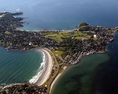
According to the United States Census Bureau, the town has a total area of 15.5 square miles (40.1 km2), of which 1.0 square mile (2.7 km2) is land and 14.4 square miles (37.4 km2), or 93.24%, is water. Nahant is a tied island connected to the mainland by a natural tombolo, effectively a peninsula though often referred to as an "island". Nahant is connected by a causeway to the city of Lynn. The town is surrounded by Nahant Bay to the east, Nahant Harbor to the south, and Lynn Harbor to the west, all of which lead directly into Broad Sound and Massachusetts Bay. The town is essentially divided into a main portion and Little Nahant, just north of the main portion of town along the eastern side of the causeway. The area along the west side of town, between Black Rock Point and Bass Point, is the most densely settled part of town. There are ten beaches along the coastline, the largest being Nahant Beach and Long Beach, both of which line the eastern side of the causeway road north of Little Nahant. The town also has a few small parks and the Kelly Greens Golf Course.
Nahant is just one of four towns out of the 351 cities and towns in Massachusetts (along with Rockport, Provincetown and Aquinnah) that only touches one other town by land (Gosnold and Nantucket do not touch any). Only touching a 400-yard portion of Lynn by land, the water rights of the town also touch those of Revere, Winthrop and Boston, in Suffolk County. Both by land and by sea, Nahant is the southernmost town in Essex County. The town is centered 14 miles (23 km) by land northeast of Boston, 9 miles (14 km) south of Salem, and 25 miles (40 km) southwest of Cape Ann.
The town has no state routes of any kind within town, one of fifteen in Massachusetts that share that distinction. The nearest state route is Route 129, within Lynn. The nearest highways are a highway portion of U.S. Route 1 in Saugus and Interstate 95 and Route 128 in Peabody. The only mass transit within town is route 439 of the MBTA Bus system, which loops within town before passing back into Lynn, providing access to Central Square, home to a stop along the Newburyport/Rockport Line of the MBTA Commuter Rail, providing service between the North Shore and Boston's North Station. The nearest airport to town is Boston's Logan International Airport.
Demographics
As of the census of 2000, there were 3,632 people, 1,629 households, and 970 families residing in the town. The population density was 2,918.7 people per square mile (1,130.9/km²). There were 1,704 housing units at an average density of 1,369.3 per square mile (530.6/km²). The racial makeup of the town was 97.11% White, 0.39% Black or African American, 0.08% Native American, 1.07% Asian, 0.06% Pacific Islander, 0.47% from other races, and 0.83% from two or more races. Hispanic or Latino of any race were 1.07% of the population.
There were 1,629 households out of which 22.5% had children under the age of 18 living with them, 49.4% were married couples living together, 7.8% had a female householder with no husband present, and 40.4% were non-families. 33.8% of all households were made up of individuals and 11.7% had someone living alone who was 65 years of age or older. The average household size was 2.20 and the average family size was 2.85.
In the town, the population was spread out with 18.6% under the age of 18, 4.0% from 18 to 24, 28.0% from 25 to 44, 29.9% from 45 to 64, and 19.4% who were 65 years of age or older. The median age was 45 years. For every 100 females there were 91.2 males. For every 100 females age 18 and over, there were 86.7 males.
The median income for a household in the town was $64,052, and the median income for a family was $76,926. Males had a median income of $52,045 versus $46,522 for females. The per capita income for the town was $41,807. About 1.4% of families and 2.6% of the population were below the poverty line, including 2.7% of those under age 18 and 2.0% of those age 65 or over.
Nahant does not have a middle or high school. Students attend grades preschool through sixth at Johnson Elementary School in Nahant. For grades seven through twelve, students attend Swampscott Middle School.
Points of interest
Annual events
In popular culture
Nahant appears in the 2015 Post Apocalyptic RPG Fallout 4.
The narrator of "Sarah's Key" (a novel by Tatiana de Rosnay) was Miss Nahant in her youth.
Actor Jason Mantzoukas is from Nahant.
Actress Barbra Fuller is from Nahant.