
Country United States Settled 1623 Elevation 77 ft (23 m) Zip code 01966 | County Essex Incorporated 1840 Time zone Eastern (UTC-5) Population 6,952 (2010) | |
 | ||
Weather 4°C, Wind NW at 13 km/h, 50% Humidity Points of interest | ||
Rockport is a town in Essex County, Massachusetts, United States. The population was 6,952 at the 2010 census. Rockport is located approximately 40 miles (64 km) northeast of Boston at the tip of the Cape Ann peninsula. It is directly east of Gloucester and is surrounded on three sides by the Atlantic Ocean.
Contents
- Map of Rockport MA USA
- History
- Notable events
- Modern Rockport
- Geography
- Demographics
- Points of interest
- Transportation
- Notable people
- Films set or filmed in Rockport
- References
Map of Rockport, MA, USA
Part of the town comprises the census-designated place of Rockport.
History
Before the coming of the English explorers and colonists, Cape Ann was home to a number of Native American villages, inhabited by members of the Agawam tribe. Samuel de Champlain named the peninsula "Cap Aux Isles" in 1605, and his expedition may have landed there briefly. By the time the first Europeans founded a permanent settlement at Gloucester in 1623, most of the Agawams had been killed by diseases caught from early contacts with Europeans.
The area that is now Rockport was simply an uninhabited part of Gloucester for more than 100 years, and was primarily used as a source of timber—especially pine-for shipbuilding. The area around Cape Ann was also one of the best fishing grounds in New England. In 1743, a dock was built at Rockport harbor on Sandy Bay and was used for both timber and fishing. By the beginning of the 19th century, the first granite quarries were developed, and by the 1830s, Rockport granite was being shipped to cities and towns throughout the East Coast of the United States.
Rockport had consisted primarily of large estates, summer homes, and a small fishing village while Gloucester was becoming increasingly urbanized. Rockport was set off as a separate town in 1840 as its residents desired a separate enclave with an identity of its own, and was incorporated in 1840. As the demand for its high-grade granite grew during the Industrial Revolution, the quarries of Rockport became a major source of the stone. A distinctive form of sloop was even developed to transport the granite to parts far and wide until the second decade of the 20th century. For many years, there was a large number of residents of Scandinavian descent, dating from the days when Finnish and Swedish immigrants with stone-working expertise made up a large part of the workforce at the quarries.
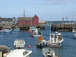
Although the demand for granite decreased with the increased use of concrete in construction during the Great Depression, Rockport still thrived as an artists colony—which began years earlier due in part to its popularity as a vacation spot known for its rocky, boulder-strewn ocean beaches, its history as a prominent fishing harbor, and its mentions in media like that of Rudyard Kipling's Captains Courageous. A red fishing shack on Bradley Wharf in Rockport, known popularly as "Motif Number 1", has for years been one of the most famous sites on Cape Ann as the subject of hundreds of paintings and photographs, and is visited by aspiring artists & tourists alike from all over the world. Rockport is the home of the Rockport Art Association.
Notable events
In 1856, a gang of 200 women led by Hannah Jumper swept through the town and destroyed anything containing alcohol in what is called "Rockport's revolt against rum" and banned alcohol from the town. Except for a period in the 1930s, the town remained one of 15 Massachusetts dry towns. The town remained dry for many years until 2005, when it was voted that alcohol could be served at restaurants, but liquor stores are still illegal.
In 1933, the Rockport American Legion Post. No. 98 built a 27-foot (8.2 m) scale model of "Motif No.1" for the Legion Parade, which was held in Chicago, Illinois, site of the 1933 World's Fair. Designed by Aldro Hibbard and Anthony Thieme, with participation by the RAA, Board of Trade and townspeople "from high to low", the float was commissioned in June, completed by the end of September, and driven in daylight only, from Rockport to Chicago, in less than a week. On October 3, 1933, among 200 floats, it won first place in the historic float competition. Upon the float's return to Rockport, a crowd of over 4,000 people lined up and down the Great Hill (5 corners) to welcome the float home.
Modern Rockport
Today Rockport is primarily a suburban residential and tourist town, but it is still home to a number of lobster fishermen and artists. Its rocky beaches and seaside parks are a favorite place for tourists from the Greater Boston Area and Rhode Island among other places.
Geography
Rockport is located at 42°39′20″N 70°37′15″W, elevation 23.46 m (77 ft). According to the United States Census Bureau, the town has a total area of 17.5 square miles (45.4 km2), of which 7.0 square miles (18.1 km2) is land and 10.5 square miles (27.3 km2), or 60.14%, is water. Rockport lies at the far eastern end of Cape Ann and is surrounded on three sides by water. There are three islands, Straitsmouth Island, Thacher Island, and Milk Island, which lie off the coast of Rockport and are part of the town. The town's shore is mostly rocky north of Lands End, but is somewhat less so south of there, as three of the town's five beaches are on this 1-1/4-mile stretch of shoreline. Rockport Harbor and Old Harbor provide deeper water for boats to dock in, both near the center of town. This provides ocean access to the fishing community. The town's highest point is atop Pool Hill, which is surrounded by the town forest. The town's other protected areas include Halibut Point State Park & Reservation, the Thacher Island National Wildlife Refuge, and the Knight Wildlife Reservation on Milk Island, as well as a smaller area just south of Halibut Point run by the Massachusetts Audubon Society.
Rockport's only neighboring town is Gloucester. Rockport is approximately 20 miles (32 km) east-northeast of Salem and 35 miles (56 km) northeast of Boston. There are no highways within town, but two state routes, Route 127 and Route 127A pass through town. Route 127 passes from north to south through town, entering inland from Gloucester, passing over Great Hill before following the sea from Back Harbor to Halibut Point and then back. Route 127A follows the southern coast into town, looping around Land's End, Gap Head and the downtown area before reaching its northern terminus at Route 127. Bus service in Rockport is provided by the Cape Ann Transportation Authority. Rockport is also the last station on its eponymous branch of the Newburyport/Rockport Line of the MBTA Commuter Rail, providing service along the North Shore to Boston's North Station. The nearest airport is the Beverly Municipal Airport, with the nearest national and international service at Boston's Logan International Airport.
Demographics
As of the census of 2000, there were 7,767 people, 3,490 households, and 2,027 families residing in the town. The population density was 1,098.9 people per square mile (424.2/km²). There were 4,202 housing units at an average density of 229.5 persons/km² (594.5 persons/sq mi). The racial makeup of the town was 97.73% White, 0.27% African American, 0.22% Native American, 0.45% Asian, 0.03% Pacific Islander, 0.51% from other races, and 0.79% from two or more races. 1.07% of the population were Hispanic or Latino of any race.
The ancestral breakdown of the residents is as follows: English (23.0%), Irish (20.4%), Italian (15.8%), German (7.1%), Scots (5.7%). The percentage of residents born outside of the United States is 6.3% (3.7% in Europe, 1.1% elsewhere in North America, 1.0% in Asia).
There were 3,490 households out of which 24.4% had children under the age of 18 living with them, 48.0% were married couples living together, 7.6% have a woman whose husband does not live with her, and 41.9% were non-families. 36.3% of all households were made up of individuals and 16.6% had someone living alone who was 65 years of age or older. The average household size was 2.20 and the average family size was 2.93.
In the town, the population was spread out with 21.3% under the age of 18, 4.4% from 18 to 24, 24.5% from 25 to 44, 29.6% from 45 to 64, and 20.2% who were 65 years of age or older. The median age was 45 years. For every 100 females there were 85.3 males. For every 100 females age 18 and over, there were 79.9 males.
The median income for a household in the town was $50,661, and the median income for a family was $69,263. Males had a median income of $46,131 versus $36,458 for females. The per capita income for the town was $29,294. 3.7% of the population and 2.5% of families were below the poverty line. Out of the total people living in poverty, 3.0% are under the age of 18 and 3.5% are 65 or older. The median house value in the town is $277,300.
Points of interest
Transportation
Rockport is served by thirteen weekday commuter trains to Boston as one terminus of the MBTA Newburyport/Rockport Line.
Bus transit throughout the area is provided by the Cape Ann Transportation Authority.