
Country Hungary County seat Salgótarján ISO 3166 code HU-NO Area code 35 | Region Northern Hungary Area rank 18th in Hungary Area 2,545 km² | |
 | ||
Postal code 2175 – 2179, 2610, 2611, 2616 – 2619, 264x – 269x, 304x – 31xx Clubs and Teams Salgótarjáni BTC, Balassagyarmati VSE Points of interest Drégely Castle, Salgó, Nógrád castle, Prirodni rezervat fosila Ipol, Csóványos Destinations Hollókő, Salgótarján, Balassagyarmat, Szécsény, Bátonyterenye | ||
Nógrád (Slovak: Novohradská) is a county (Hungarian: megye) of Hungary.
Contents
- Map of NC3B3grC3A1d Hungary
- Description
- History
- Demographics
- Ethnicity
- Religion
- Politics
- City with county rights
- Towns
- References
Map of N%C3%B3gr%C3%A1d, Hungary
Description
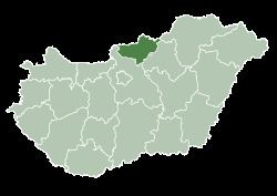
Nógrád county lies in northern Hungary. It shares borders with Slovakia and the Hungarian counties Pest, Heves and Borsod-Abaúj-Zemplén. The capital of Nógrád county is Salgótarján. Its area is 2,544 km².
Nógrád is famous for its historic architecture of ancient Gothic churches and stone castles dated to the 13th century. Other historic landmark includes the baroque buildings constructed in the 18th century and the Vay, Teleki. Much of the northern border of the county is formed by the river Ipoly. The mountain ranges Börzsöny, Cserhát and Mátra lie partly in the county.
Due to the mountains, the county is characterised by small villages nestled in the valleys. The two largest settlements are Balassagyarmat, the former county seat, and Salgótarján, which has become a center of industry in the early 20th century due to coal mines nearby.
History
Nógrád (-Hungarian, in Latin: comitatus Neogradiensis, in German: Neuburg or Neograd, in Slovak: Novohrad) was also the name of a historic administrative county (comitatus) of the Kingdom of Hungary. Its territory is now in southern Slovakia and in northern present-day Hungary. The name Novohrad is still used in Slovakia as an informal designation of the corresponding territory. The name stems from the former Nógrád (Novohrad) castle in present-day Hungary.
Demographics
In 2015, it had a population of 195,923 and the population density was 77/km².
Ethnicity
Besides the Hungarian majority, the main minorities are the Roma (approx. 15,000), Slovaks (2,500) and Germans (1,000).
Total population (2011 census): 202,427
Ethnic groups (2011 census): Identified themselves: 192 438 persons:
Approx. 26,000 persons in Nógrád County did not declare their ethnic group at the 2011 census.
Religion
Religious adherence in the county according to 2011 census:
Politics
The regional legislature is the General Assembly.
The Nógrád County Council, elected at the 2014 local government elections, is made up of 15 counselors, with the following party composition:
City with county rights
Towns
(ordered by population, as of 2011 census)