
Max. length 40 km (25 mi) Surface elevation 95 m Length 40 km | Max. depth 63 m (207 ft) Area 256.1 km² Catchment area 7,672 km² | |
 | ||
Surface area 256.12 km (98.89 sq mi) Cities Tampere, Ylöjärvi, Kuru, Finland | ||
Fishing in finland crayfishing on lake n sij rvi
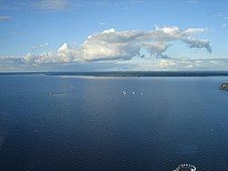
Näsijärvi is a lake 95 metres (312 ft) above sea level, in the Pirkanmaa region of southern Finland. Näsijärvi is the biggest lake in the Tampere area at 256 square kilometres (99 sq mi) in size. The city of Tampere was built along the Tammerkoski rapids, through which the lake drains into Pyhäjärvi. The water quality of the lake has improved as forest industry has decreased the amount of waste water.
Contents
- Fishing in finland crayfishing on lake n sij rvi
- Map of NC3A4sijC3A4rvi Finland
- Storm n sij rvi in tampere finland 23 9 2014
- References
Map of N%C3%A4sij%C3%A4rvi, Finland
There are boat cruising services on Näsijärvi. In 1929, the steamer SS Kuru suffered the most severe Finnish inland shipping disaster on Näsijärvi.
During the winter, usually during February and March, the lake is frozen in its entirety. Näsijärvi is then used for Nordic walking, cross-country skiing, and everyday pleasure walking. There is a small, rocky island upon which a lighthouse, called Siilinkari, is located; it is the most popular walking destination on the lake.
In the north Näsijärvi has a wide catchment area that includes among others the lakes Ruovesi, Kuorevesi, Keurusselkä, Tarjanne, Pihlajavesi, Toisvesi and Ähtärinjärvi.