
Elevation 1,981 m (6,499 ft) | Length 40 km (25 mi) Country Austria | |
 | ||
Similar Alps, Gutenstein Alps, Ennstal Alps, Hochschwab Mountains, Bregenz Forest Mountains | ||
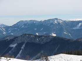
The Mürzsteg Alps or Mürztal Alps (German: Mürztaler or Mürzsteger Alpen) are a mountain range in the Eastern Alps (Northern Limestone Alps), which lie in the Austrian state of Styria, with a small part of the range in Lower Austria. The highest peak is the Hohe Veitsch (1,981 m (AA)) in the centre of the group, while largest massif is the Schneealpe (1,903 m (AA)) in the northwest, near the Rax.
Contents
Map of M%C3%BCrzsteg Alps, 8663 St. Barbara im M%C3%BCrztal, Austria
The following ranges border on the Mürzsteg Alps: to the north the Türnitz Alps, to the northeast the Gutenstein Alps, to the east the Rax-Schneeberg Group, to the southeast the Prealps east of the Mur (specifically the Fischbach Alps) and to the west the Hochschwab Mountains.
Geology
The range is part of the Styrian-Lower Austrian Limestone Alps and is separated from its neighbouring groups by the Mürz valley (part of the tectonically active Mur-Mürz Furrow), the upper reaches of the Mürz (main settlement: Mürzsteg) and the road over the Styrian Seeberg Pass. It is described by geologists as a ridge-and-basin facies.
The majority of its rocks date to the Triassic period and include Wetterstein Dolomite, Hallstatt Limestone and Mürztal strata (dark, hornstein-dominated limestones and marls with foraminifers, brachiopods and other fossils).
The south of the range belong to the greywacke zone (rocks from the New Palaeozoic and the Lower Triassic).