Founded 1096 Elevation 305 m (1,001 ft) Area 4 km² Local time Thursday 8:17 AM | Town status 1939 Time zone EET (UTC+2) Population 3,457 (2001) | |
 | ||
Weather 6°C, Wind NE at 11 km/h, 95% Humidity | ||
Mykulyntsi (Ukrainian: Микулинці; Polish: Mikulińce) is an urban-type settlement in the Terebovlia Raion (district) of Ternopil Oblast (province) in western Ukraine. Its population is 3,457 as of the 2001 Ukrainian Census. The town lies on the banks of the Seret River, a tributary of the Dnister.
Contents
Map of Mykulyntsi, Ternopil Oblast, Ukraine
A settlement named Mykulyn (Ukrainian: Микулин) was first mentioned in 1096 in Vladimir Monomakh's "Guidelines" during times of the Kievan Rus' in what is now the town's current location. In 1387, the settlement was then called by its current name—Mykulyntsi. In 1595, Mykulyntsi acquired the Magdeburg rights, which was later relinquished during the Polish-Ottoman Wars, so at the request of Augustus III of Poland, Mykulyntsi regained the rights on 16 December 1758. In 1939, the settlement was upgraded to that of an urban-type settlement, which it has been since.
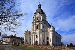
In the town there are ruins of an old castle, which dates back to 1610. The castle was rebuilt in the 18th century, but by the beginning of the 20th century, the fortification served no use and it was left to disrepair. There is also the Baroque Trinity Church in Mykulyntsi, which was designed by architect Polish August Moszyński and built from 1761–1779.
People from Mykulyntsi
Twin towns – Sister cities
Mykulyntsi is twinned with
