
 | ||
Downeast magazine discusses munjoy hill in portland
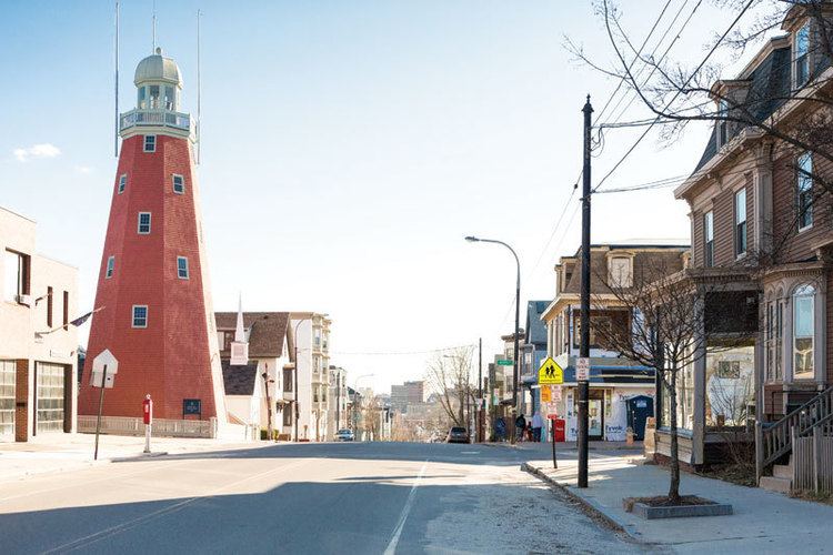
Munjoy Hill is a neighborhood and prominent geographical feature of Portland, Maine. It is located east of downtown, and south of East Deering, the neighborhood it is connected to by Tukey's Bridge. The neighborhood historically had a large Irish and Italian American population.
Contents
- Downeast magazine discusses munjoy hill in portland
- Map of Munjoy Hill Portland ME 04101 USA
- Eastern prom munjoy hill real estate tour portland maine
- Geography
- Prominent buildings
- Education
- Parks
- Fort Allen Park
- Notable residents
- References
Map of Munjoy Hill, Portland, ME 04101, USA
Eastern prom munjoy hill real estate tour portland maine
Geography
At the northeastern end of Portland's peninsula, Munjoy Hill overlooks the downtown and harbor to the south, Casco Bay and its islands to the east and north, and shallow Back Cove to the west. The Eastern Promenade rings the neighborhood and offers panoramic views of these features, as well as two lighthouses, Mason Station power plant, and the stone battlement of Fort Gorges.
Though less than a mile from the heart of downtown Portland and Interstate Highway 295, Munjoy Hill is relatively free of traffic. While densely settled, it is almost exclusively residential and due to the shape of the peninsula it is isolated from the major commuter routes. Congress Street, downtown Portland's main artery, ends quietly at the Eastern Promenade. Washington Avenue, crossing from the other side of Back Cove, might be considered the boundary of the neighborhood, with Fox Street and India Street areas merging into the downtown and Bayside areas.
The most significant land feature of Munjoy Hill is the magnificent Eastern Promenade, a park designed by the Olmsted Brothers design firm, as was Baxter Boulevard, which rings part of Back Cove. This Olmsted park has amazing water vistas wrapping from the sunset view at the Loring memorial above the shore for over a mile to a sunrise view over the Calendar Islands of Casco Bay and Portland Head Light, and ending at Fort Allen Park with a full sweep of Portland Harbor. The park includes a series of broad rolling fields, public gardens, monuments, playgrounds and ball courts on top of the bluff and, along the waterfront, East End Beach, picnic areas, and a municipal boat launch. The Maine Narrow Gauge Railroad Co. & Museum operates 2 foot gauge steam and diesel tourist trains along the Casco Bay shore of the peninsula. The shoreway trail, which begins in South Portland, runs next to the railroad line and connects with the Baxter Boulevard trail, all suitable for walking, running, and cycling. The small public beach is a favorite of kayakers, families, and, after 5 PM, dog owners and their pets. The launch is often used to ferry heavy equipment to the city's outlying islands, including Peaks, Little Diamond and Great Diamond Islands. Near the northern end of the Eastern Promenade, a monument to Korean War pilot Charles J. Loring, Jr. offers sunset viewing over Back Cove, plus an occasional glimpse of Mount Washington, about 70 miles (110 km) away in New Hampshire's White Mountains. Another park on North Street offers views of downtown.
The East End Beach is a small beach on the eastern side of Munjoy Hill.
Prominent buildings
At the center of Munjoy Hill, on the corner of Congress, between Kellogg and St Lawrence Streets, are the Portland Observatory, the neighborhood fire station (housing Engine 1, Ladder 1, and Ladder 5) and Collucci's Market. Nearby on Congress Street are a laundromat, Rosemont Market, Hilltop Coffee, and three restaurants—The Blue Spoon, The Front Room, and Bar Lola.
Housing in the neighborhood is a mix of single- and multi-family structures. There are many triple-deckers, especially on Vesper, Morning, and North Streets. Many of these are rental units, with some condominiums. Only a small proportion have more than three units.
Until recently (March 2006) the neighborhood had two elementary schools, Jack and Adams. Jack was found to be contaminated with mold, closed and was demolished. Its students were relocated to other city schools pending the construction of a unified East End School to replace both Jack and Adams. The East End School opened to students in September 2006. The local polling place and public library branch services from the Adams school were moved to the East End School as well. The Portland Public Library's Munjoy Hill branch, within the East End school, was closed in 2010. The space now holds the school's own library.
There is a small, arts-based, neighborhood preschool, on Lafayette Street, called The Schoolhouse.
The St. Lawrence Arts Center is home to "Good Theater," productions and other arts events year round.
Education
Beginning in 2006, the neighborhood was served by the East End Community School, which was built following the closure of Jack Elementary School and Marada Adams School.
Parks
Munjoy Hill is home to a number of parks. The Eastern Promenade is one of Portland's most scenic and highly used public spaces. Other parks include Fort Sumner Park (also called Standpipe Park) on North Street. (The place called "Standpipe" park is now privately owned, and the origin of the name is unknown to this writer. In the 50's and 60's - perhaps earlier - neighbors referred to it as "Shailer Park", probably due to it being next door to Shailer School. When publicly owned, it was officially Fort Sumner Park, named for the fort which had been located there. The area at the end of North Street shown on many maps as Fort Sumner Park, is not, and in fact, was never named at all. There was a stand pipe in the area, but it, and a reservoir, was located at the corner of North and Walnut Street where there are now apartments.)
Fort Allen Park
Fort Allen Park, which covers 9 acres (3.6 ha) and abuts the Eastern Promenade to the south, was built in the 1890s, designed by the city's Chief Engineer William Goodwin and backed by Mayor James P. Baxter, according to a plaque in the park. Fort Allen was probably originally built in 1775, may have served as part of Fort Sumner, and was rebuilt by the city and used to guard Portland during the War of 1812 due to its high vantage point overlooking Casco Bay. The park is home to a 6-inch gun from the USS Maine (the ship whose explosion in Havana, Cuba started the Spanish–American War), the foremast and bridge structure of the World War II cruiser USS Portland (CA-33), two Civil War-era 4.5-inch siege rifles, an American Civil War memorial bench erected in 1929, and an historic bandstand which was built in the 1890s. In 2012, a local non-profit group, Friends of the Eastern Promenade, sought to restore Fort Allen Park to its original look. As of 2016 this has resulted in additional interpretive plaques throughout the park, along with other improvements.
Some sources state that Fort Allen dates from 1775 and was originally named for Revolutionary War hero Ethan Allen. It was initially a half-moon battery mounting five guns. After 1794 it may have served as the "detached battery" of nearby Fort Sumner, as described in the Secretary of War's report for 1811. Fort Allen was rebuilt in 1814 with city resources, adding a magazine and barracks due to the British capture of Eastport and Castine in the War of 1812. A plaque at the park states that at this time it was named for Master Commandant William Henry Allen, a naval officer mortally wounded in the War of 1812.