
Max. width 6 kilometres (3.7 mi) Surface elevation 820 m Width 6 km | Max. length 12 kilometres (7.5 mi) Max. depth 223 m (732 ft) Length 12 km Inflow source Trout River | |
 | ||
Primary inflows Cities Muncho Lake, British Columbia | ||
Drivelapse alaska highway muncho lake bc to liard river hotsprings provincial park bc
Muncho Lake is a lake in northern British Columbia, Canada.
Contents
- Drivelapse alaska highway muncho lake bc to liard river hotsprings provincial park bc
- Map of Muncho Lake Northern Rockies B BC Canada
- Between muncho lake liard hot springs bc produced by erick f dircks
- References
Map of Muncho Lake, Northern Rockies B, BC, Canada
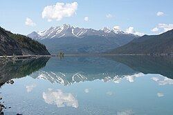
The lake is part of the Muncho Lake Provincial Park and located at kilometre 681 (mile 423) of the Alaska Highway. The lake is about 12 km (7.5 mi) long and its width varies between 1 and 6 km. It reaches a maximum depth of 223 m (732 ft). The surrounding peaks (the Terminal Range of the Muskwa Ranges to the west and the Sentinel Range to the east) reach altitudes of more than 2,000 m (6,600 ft), while the lake lies at an elevation of 820 m (2,690 ft). It is formed along the Trout River, a tributary of the Liard River.
The jade green color of the lake is attributed to the presence of copper oxide leached from the bedrock underneath. Its name is derived from the Kaska language in which "muncho" translates as "big water".
The small community of Muncho Lake is established on the lake's southern shore, at the confluence of Trout River and Muncho Creek. The Muncho Lake/Mile 462 Water Aerodrome is set up along the eastern shore of the lake, at Mile 462 of the Alaska Highway.