
Country Philippines Barangays ZIP code 4312 Population 53,123 (2015) Province Quezon | District 3rd district of Quezon Time zone PST (UTC+8) Area 420 km² Local time Tuesday 4:52 PM Dialling code 42 | |
 | ||
Region CALABARZON (Region IV-A) Weather 26°C, Wind NW at 11 km/h, 82% Humidity University Polytechnic University of the Philippines Mulanay | ||
Mulanay is a first class suburban municipality in the province of Quezon, Philippines. According to the 2015 census, it has a population of 53,123 people.
Contents
Map of Mulanay, Quezon, Philippines
This place is situated on the Bondoc Peninsula; its geographical coordinates are 13° 31′ 20″ North, 122° 24′ 15″ East, and its original name was Malunay. Mulanay is about 100 kilometres (62 mi) south-east from Lucena City.
The town proper, with her plain landscape, is a coastal town facing the Tayabas Bay.
Barangays
Mulanay is politically subdivided into 28 barangays.
History
A 10th-century burial site was discovered in the Kamhantik forest which signified an early settlement around the mountain.
Some legends would relate Mulanay to have derived its name from the Tagalog word Malunay, which means "Plenty of Lunay". Lunay is the vernacular term for Pili wax, which was abundant in the area.
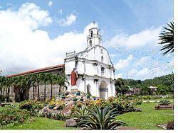
In 1600, Franciscan missionaries evangelized the area for the Roman Catholic Church. However, its civil foundation as a municipality effected only in 1745 thru the approval of the King of Spain as contained in his royal decree. This town at that time, encompasses the municipal territories of San Narciso, San Francisco, Catanauan and which if measured will be as big as the province of Bataan. The original town of Mulanay was composed of only six barangays.
The first town head of Mulanay during the Spanish regime was Alcalde Mayor Bustaquio Manlangit, while the first town mayor during the American occupation was Mayor Atanacio Ojeda. At present, Mulanay is composed of a total 28 barangays, four of which comprised the town proper.
Local government
Elected officials 2013–2016: